You are here: Home > Network List > US - United States National Seismic Network Stations List
> Station EGMT Eagleton, Montana, USA > Earthquake Result Viewer
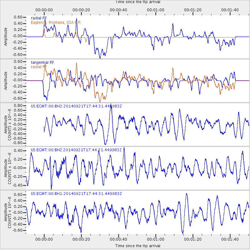
EGMT Eagleton, Montana, USA - Earthquake Result Viewer
*The percent match for this event was below the threshold and hence no stack was calculated.
| Earthquake location: |
Bonin Islands, Japan Region |
| Earthquake latitude/longitude: |
28.0/139.8 |
| Earthquake time(UTC): |
2014/09/21 (264) 17:33:34 GMT |
| Earthquake Depth: |
492 km |
| Earthquake Magnitude: |
4.9 mb |
| Earthquake Catalog/Contributor: |
ISC/ISC |
|
| Network: |
US United States National Seismic Network |
| Station: |
EGMT Eagleton, Montana, USA |
| Lat/Lon: |
48.02 N/109.75 W |
| Elevation: |
1055 m |
|
| Distance: |
82.0 deg |
| Az: |
39.434 deg |
| Baz: |
303.171 deg |
| Ray Param: |
$rayparam |
*The percent match for this event was below the threshold and hence was not used in the summary stack. |
|
| Radial Match: |
52.79051 % |
| Radial Bump: |
400 |
| Transverse Match: |
69.842896 % |
| Transverse Bump: |
400 |
| SOD ConfigId: |
3390531 |
| Insert Time: |
2019-04-14 04:05:07.096 +0000 |
| GWidth: |
2.5 |
| Max Bumps: |
400 |
| Tol: |
0.001 |
|
Signal To Noise
| Channel | StoN | STA | LTA |
| US:EGMT:00:BHZ:20140921T17:44:31.449983Z | 0.9988717 | 1.8208381E-7 | 1.8228948E-7 |
| US:EGMT:00:BH1:20140921T17:44:31.449983Z | 0.6869091 | 1.5542557E-7 | 2.2626804E-7 |
| US:EGMT:00:BH2:20140921T17:44:31.449983Z | 2.305062 | 4.912219E-7 | 2.1310572E-7 |
| Arrivals |
| Ps | |
| PpPs | |
| PsPs/PpSs | |


