You are here: Home > Network List > TA - USArray Transportable Network (new EarthScope stations) Stations List
> Station E58A La Victoria, QC, CAN > Earthquake Result Viewer
E58A La Victoria, QC, CAN - Earthquake Result Viewer
| Earthquake location: |
Near East Coast Of Honshu, Japan |
| Earthquake latitude/longitude: |
38.2/141.9 |
| Earthquake time(UTC): |
2013/08/04 (216) 03:28:50 GMT |
| Earthquake Depth: |
56 km |
| Earthquake Magnitude: |
5.8 MW, 5.8 MB, 5.9 MW |
| Earthquake Catalog/Contributor: |
NEIC PDE/NEIC PDE-W |
|
| Network: |
TA USArray Transportable Network (new EarthScope stations) |
| Station: |
E58A La Victoria, QC, CAN |
| Lat/Lon: |
46.37 N/73.28 W |
| Elevation: |
233 m |
|
| Distance: |
90.1 deg |
| Az: |
23.486 deg |
| Baz: |
333.039 deg |
| Ray Param: |
0.04168906 |
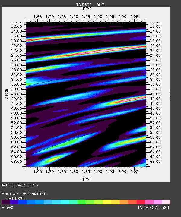
| Estimated Moho Depth: |
21.75 km |
| Estimated Crust Vp/Vs: |
1.93 |
| Assumed Crust Vp: |
6.61 km/s |
| Estimated Crust Vs: |
3.42 km/s |
| Estimated Crust Poisson's Ratio: |
0.32 |
|
| Radial Match: |
85.39217 % |
| Radial Bump: |
400 |
| Transverse Match: |
61.966297 % |
| Transverse Bump: |
400 |
| SOD ConfigId: |
589702 |
| Insert Time: |
2013-09-25 00:03:57.931 +0000 |
| GWidth: |
2.5 |
| Max Bumps: |
400 |
| Tol: |
0.001 |
|

Signal To Noise
| Channel | StoN | STA | LTA |
| TA:E58A: :BHZ:20130804T03:41:13.399985Z | 8.308315 | 6.229786E-7 | 7.498254E-8 |
| TA:E58A: :BHN:20130804T03:41:13.399985Z | 3.3426545 | 1.7229912E-7 | 5.1545598E-8 |
| TA:E58A: :BHE:20130804T03:41:13.399985Z | 1.5091119 | 1.06322794E-7 | 7.0453886E-8 |
| Arrivals |
| Ps | 3.1 SECOND |
| PpPs | 9.5 SECOND |
| PsPs/PpSs | 13 SECOND |


