You are here: Home > Network List > TA - USArray Transportable Network (new EarthScope stations) Stations List
> Station G45A Suttons Bay, MI, USA > Earthquake Result Viewer
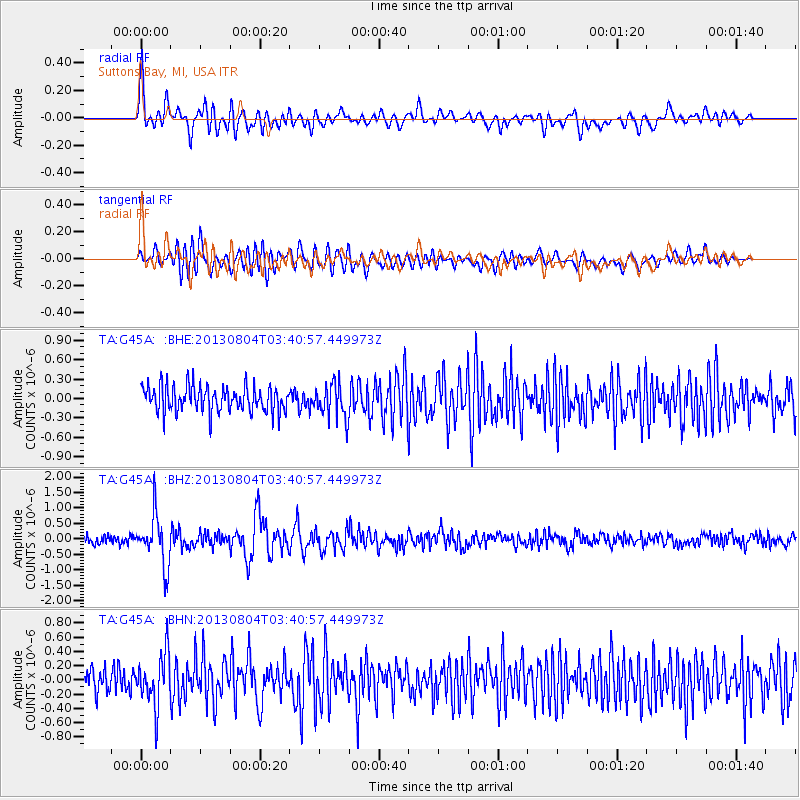
G45A Suttons Bay, MI, USA - Earthquake Result Viewer
*The percent match for this event was below the threshold and hence no stack was calculated.
| Earthquake location: |
Near East Coast Of Honshu, Japan |
| Earthquake latitude/longitude: |
38.2/141.9 |
| Earthquake time(UTC): |
2013/08/04 (216) 03:28:50 GMT |
| Earthquake Depth: |
56 km |
| Earthquake Magnitude: |
5.8 MW, 5.8 MB, 5.9 MW |
| Earthquake Catalog/Contributor: |
NEIC PDE/NEIC PDE-W |
|
| Network: |
TA USArray Transportable Network (new EarthScope stations) |
| Station: |
G45A Suttons Bay, MI, USA |
| Lat/Lon: |
45.04 N/85.66 W |
| Elevation: |
284 m |
|
| Distance: |
86.7 deg |
| Az: |
31.583 deg |
| Baz: |
324.415 deg |
| Ray Param: |
$rayparam |
*The percent match for this event was below the threshold and hence was not used in the summary stack. |
|
| Radial Match: |
75.86292 % |
| Radial Bump: |
400 |
| Transverse Match: |
65.93012 % |
| Transverse Bump: |
400 |
| SOD ConfigId: |
589702 |
| Insert Time: |
2013-09-25 00:04:39.642 +0000 |
| GWidth: |
2.5 |
| Max Bumps: |
400 |
| Tol: |
0.001 |
|
Signal To Noise
| Channel | StoN | STA | LTA |
| TA:G45A: :BHZ:20130804T03:40:57.449973Z | 5.363658 | 8.1535177E-7 | 1.5201414E-7 |
| TA:G45A: :BHN:20130804T03:40:57.449973Z | 2.4509592 | 3.6319273E-7 | 1.4818391E-7 |
| TA:G45A: :BHE:20130804T03:40:57.449973Z | 1.350441 | 2.707053E-7 | 2.0045697E-7 |
| Arrivals |
| Ps | |
| PpPs | |
| PsPs/PpSs | |


