You are here: Home > Network List > TA - USArray Transportable Network (new EarthScope stations) Stations List
> Station L40A Anamosa, IA, USA > Earthquake Result Viewer
L40A Anamosa, IA, USA - Earthquake Result Viewer
| Earthquake location: |
Near East Coast Of Honshu, Japan |
| Earthquake latitude/longitude: |
38.2/141.9 |
| Earthquake time(UTC): |
2013/08/04 (216) 03:28:50 GMT |
| Earthquake Depth: |
56 km |
| Earthquake Magnitude: |
5.8 MW, 5.8 MB, 5.9 MW |
| Earthquake Catalog/Contributor: |
NEIC PDE/NEIC PDE-W |
|
| Network: |
TA USArray Transportable Network (new EarthScope stations) |
| Station: |
L40A Anamosa, IA, USA |
| Lat/Lon: |
42.06 N/91.22 W |
| Elevation: |
242 m |
|
| Distance: |
86.6 deg |
| Az: |
36.612 deg |
| Baz: |
320.884 deg |
| Ray Param: |
0.043815035 |
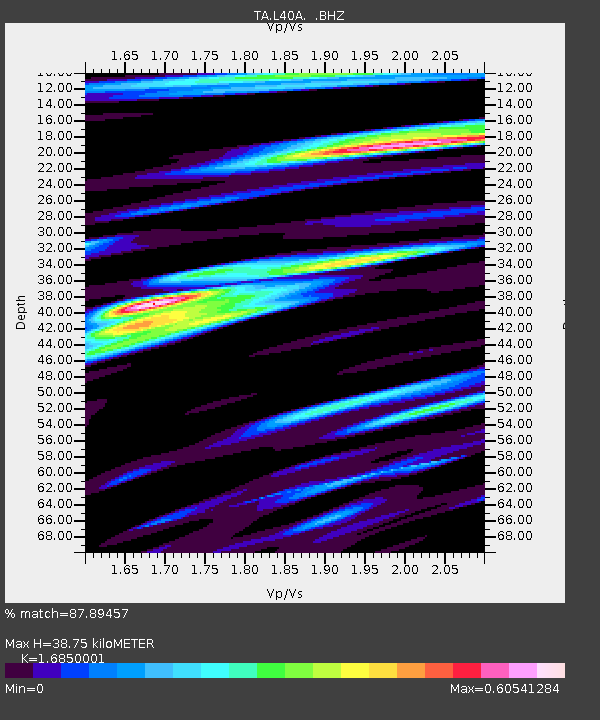
| Estimated Moho Depth: |
38.75 km |
| Estimated Crust Vp/Vs: |
1.69 |
| Assumed Crust Vp: |
6.53 km/s |
| Estimated Crust Vs: |
3.876 km/s |
| Estimated Crust Poisson's Ratio: |
0.23 |
|
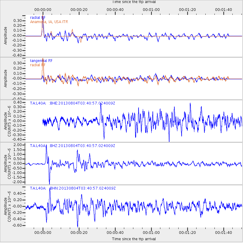
| Radial Match: |
87.89457 % |
| Radial Bump: |
400 |
| Transverse Match: |
76.91529 % |
| Transverse Bump: |
400 |
| SOD ConfigId: |
589702 |
| Insert Time: |
2013-09-25 00:07:18.145 +0000 |
| GWidth: |
2.5 |
| Max Bumps: |
400 |
| Tol: |
0.001 |
|
Signal To Noise
| Channel | StoN | STA | LTA |
| TA:L40A: :BHZ:20130804T03:40:57.024009Z | 12.069669 | 8.4144705E-7 | 6.971584E-8 |
| TA:L40A: :BHN:20130804T03:40:57.024009Z | 4.8720355 | 2.1464307E-7 | 4.4056137E-8 |
| TA:L40A: :BHE:20130804T03:40:57.024009Z | 2.5919385 | 1.5592796E-7 | 6.0158825E-8 |
| Arrivals |
| Ps | 4.2 SECOND |
| PpPs | 16 SECOND |
| PsPs/PpSs | 20 SECOND |


