You are here: Home > Network List > IU - Global Seismograph Network (GSN - IRIS/USGS) Stations List
> Station POHA Pohakuloa, Hawaii, USA > Earthquake Result Viewer
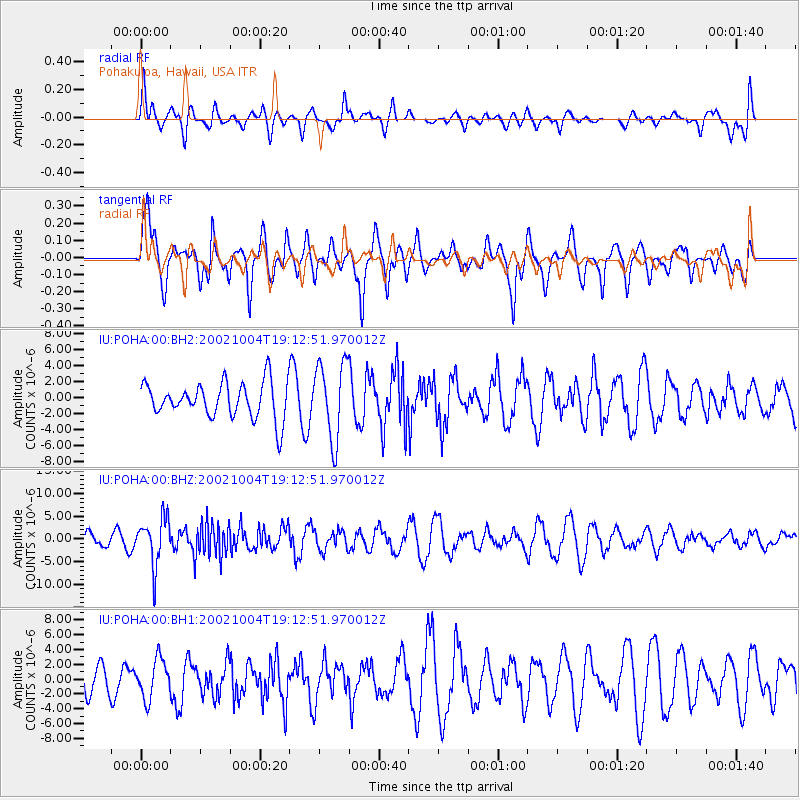
POHA Pohakuloa, Hawaii, USA - Earthquake Result Viewer
*The percent match for this event was below the threshold and hence no stack was calculated.
| Earthquake location: |
Fiji Islands Region |
| Earthquake latitude/longitude: |
-21.0/-179.0 |
| Earthquake time(UTC): |
2002/10/04 (277) 19:05:48 GMT |
| Earthquake Depth: |
621 km |
| Earthquake Magnitude: |
6.1 MB, 6.3 MW, 6.3 MW |
| Earthquake Catalog/Contributor: |
WHDF/NEIC |
|
| Network: |
IU Global Seismograph Network (GSN - IRIS/USGS) |
| Station: |
POHA Pohakuloa, Hawaii, USA |
| Lat/Lon: |
19.76 N/155.53 W |
| Elevation: |
1967 m |
|
| Distance: |
46.6 deg |
| Az: |
31.121 deg |
| Baz: |
210.849 deg |
| Ray Param: |
$rayparam |
*The percent match for this event was below the threshold and hence was not used in the summary stack. |
|
| Radial Match: |
32.90898 % |
| Radial Bump: |
347 |
| Transverse Match: |
65.833595 % |
| Transverse Bump: |
400 |
| SOD ConfigId: |
590571 |
| Insert Time: |
2013-09-25 00:07:52.133 +0000 |
| GWidth: |
2.5 |
| Max Bumps: |
400 |
| Tol: |
0.001 |
|
Signal To Noise
| Channel | StoN | STA | LTA |
| IU:POHA:00:BHZ:20021004T19:12:51.970012Z | 2.3956943 | 5.222107E-6 | 2.1797885E-6 |
| IU:POHA:00:BH1:20021004T19:12:51.970012Z | 0.9657852 | 2.6415166E-6 | 2.7350975E-6 |
| IU:POHA:00:BH2:20021004T19:12:51.970012Z | 2.185172 | 4.829132E-6 | 2.209955E-6 |
| Arrivals |
| Ps | |
| PpPs | |
| PsPs/PpSs | |


