You are here: Home > Network List > TA - USArray Transportable Network (new EarthScope stations) Stations List
> Station N41A Harden Midland Farm, Stronghurst, IL, USA > Earthquake Result Viewer
N41A Harden Midland Farm, Stronghurst, IL, USA - Earthquake Result Viewer
| Earthquake location: |
Near East Coast Of Honshu, Japan |
| Earthquake latitude/longitude: |
38.2/141.9 |
| Earthquake time(UTC): |
2013/08/04 (216) 03:28:50 GMT |
| Earthquake Depth: |
56 km |
| Earthquake Magnitude: |
5.8 MW, 5.8 MB, 5.9 MW |
| Earthquake Catalog/Contributor: |
NEIC PDE/NEIC PDE-W |
|
| Network: |
TA USArray Transportable Network (new EarthScope stations) |
| Station: |
N41A Harden Midland Farm, Stronghurst, IL, USA |
| Lat/Lon: |
40.71 N/90.86 W |
| Elevation: |
226 m |
|
| Distance: |
87.9 deg |
| Az: |
37.25 deg |
| Baz: |
321.156 deg |
| Ray Param: |
0.04292268 |
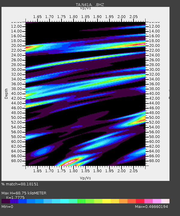
| Estimated Moho Depth: |
68.75 km |
| Estimated Crust Vp/Vs: |
1.78 |
| Assumed Crust Vp: |
6.498 km/s |
| Estimated Crust Vs: |
3.655 km/s |
| Estimated Crust Poisson's Ratio: |
0.27 |
|
| Radial Match: |
88.18151 % |
| Radial Bump: |
400 |
| Transverse Match: |
67.42375 % |
| Transverse Bump: |
400 |
| SOD ConfigId: |
589702 |
| Insert Time: |
2013-09-25 00:08:48.062 +0000 |
| GWidth: |
2.5 |
| Max Bumps: |
400 |
| Tol: |
0.001 |
|

Signal To Noise
| Channel | StoN | STA | LTA |
| TA:N41A: :BHZ:20130804T03:41:02.92501Z | 11.154124 | 8.889392E-7 | 7.969601E-8 |
| TA:N41A: :BHN:20130804T03:41:02.92501Z | 3.3025033 | 2.8457941E-7 | 8.6170814E-8 |
| TA:N41A: :BHE:20130804T03:41:02.92501Z | 2.6460733 | 2.0740848E-7 | 7.838349E-8 |
| Arrivals |
| Ps | 8.4 SECOND |
| PpPs | 29 SECOND |
| PsPs/PpSs | 37 SECOND |


