You are here: Home > Network List > IU - Global Seismograph Network (GSN - IRIS/USGS) Stations List
> Station RSSD Black Hills, South Dakota, USA > Earthquake Result Viewer
RSSD Black Hills, South Dakota, USA - Earthquake Result Viewer
*The percent match for this event was below the threshold and hence no stack was calculated.
| Earthquake location: |
Reykjanes Ridge |
| Earthquake latitude/longitude: |
58.3/-31.9 |
| Earthquake time(UTC): |
2002/10/07 (280) 20:03:54 GMT |
| Earthquake Depth: |
10 km |
| Earthquake Magnitude: |
5.6 MW, 5.5 MS, 5.7 MW |
| Earthquake Catalog/Contributor: |
NEIC PDE/NEIC PDE-M |
|
| Network: |
IU Global Seismograph Network (GSN - IRIS/USGS) |
| Station: |
RSSD Black Hills, South Dakota, USA |
| Lat/Lon: |
44.12 N/104.04 W |
| Elevation: |
2060 m |
|
| Distance: |
45.1 deg |
| Az: |
284.568 deg |
| Baz: |
45.183 deg |
| Ray Param: |
$rayparam |
*The percent match for this event was below the threshold and hence was not used in the summary stack. |
|
| Radial Match: |
61.158978 % |
| Radial Bump: |
400 |
| Transverse Match: |
64.71098 % |
| Transverse Bump: |
400 |
| SOD ConfigId: |
590571 |
| Insert Time: |
2013-09-25 00:09:26.816 +0000 |
| GWidth: |
2.5 |
| Max Bumps: |
400 |
| Tol: |
0.001 |
|
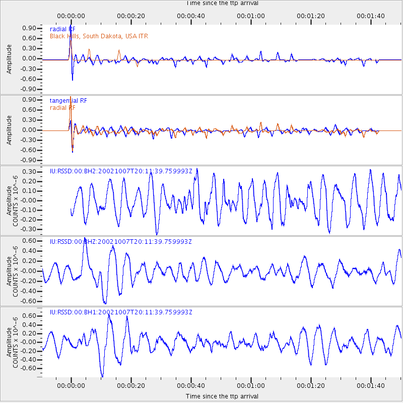
Signal To Noise
| Channel | StoN | STA | LTA |
| IU:RSSD:00:BHZ:20021007T20:11:39.759993Z | 1.7452269 | 2.6342408E-7 | 1.5093973E-7 |
| IU:RSSD:00:BH1:20021007T20:11:39.759993Z | 0.9345404 | 9.159955E-8 | 9.801561E-8 |
| IU:RSSD:00:BH2:20021007T20:11:39.759993Z | 0.8917657 | 1.15233576E-7 | 1.2921956E-7 |
| Arrivals |
| Ps | |
| PpPs | |
| PsPs/PpSs | |


