You are here: Home > Network List > IU - Global Seismograph Network (GSN - IRIS/USGS) Stations List
> Station POHA Pohakuloa, Hawaii, USA > Earthquake Result Viewer
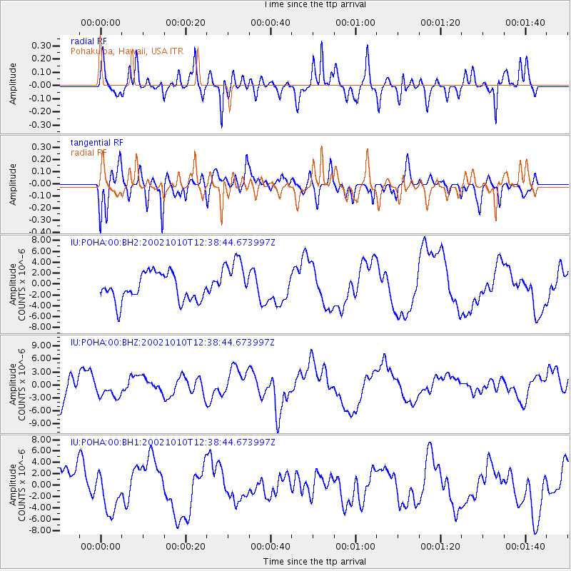
POHA Pohakuloa, Hawaii, USA - Earthquake Result Viewer
*The percent match for this event was below the threshold and hence no stack was calculated.
| Earthquake location: |
Irian Jaya Region, Indonesia |
| Earthquake latitude/longitude: |
-1.5/134.2 |
| Earthquake time(UTC): |
2002/10/10 (283) 12:27:52 GMT |
| Earthquake Depth: |
10 km |
| Earthquake Magnitude: |
5.5 MB |
| Earthquake Catalog/Contributor: |
NEIC PDE/NEIC PDE-M |
|
| Network: |
IU Global Seismograph Network (GSN - IRIS/USGS) |
| Station: |
POHA Pohakuloa, Hawaii, USA |
| Lat/Lon: |
19.76 N/155.53 W |
| Elevation: |
1967 m |
|
| Distance: |
72.0 deg |
| Az: |
68.782 deg |
| Baz: |
261.661 deg |
| Ray Param: |
$rayparam |
*The percent match for this event was below the threshold and hence was not used in the summary stack. |
|
| Radial Match: |
61.07598 % |
| Radial Bump: |
400 |
| Transverse Match: |
54.52773 % |
| Transverse Bump: |
400 |
| SOD ConfigId: |
590571 |
| Insert Time: |
2013-09-25 00:11:21.245 +0000 |
| GWidth: |
2.5 |
| Max Bumps: |
400 |
| Tol: |
0.001 |
|
Signal To Noise
| Channel | StoN | STA | LTA |
| IU:POHA:00:BHZ:20021010T12:38:44.673997Z | 0.60797286 | 1.9243587E-6 | 3.165205E-6 |
| IU:POHA:00:BH1:20021010T12:38:44.673997Z | 1.2590518 | 3.5886706E-6 | 2.8502961E-6 |
| IU:POHA:00:BH2:20021010T12:38:44.673997Z | 1.7501327 | 4.3001332E-6 | 2.4570327E-6 |
| Arrivals |
| Ps | |
| PpPs | |
| PsPs/PpSs | |


