You are here: Home > Network List > ZJ12 - Transantarctic Mountains Northern Network Stations List
> Station RAPH Exposure Hill, Antarctica > Earthquake Result Viewer
RAPH Exposure Hill, Antarctica - Earthquake Result Viewer
| Earthquake location: |
South Sandwich Islands Region |
| Earthquake latitude/longitude: |
-56.0/-27.8 |
| Earthquake time(UTC): |
2014/09/22 (265) 16:01:42 GMT |
| Earthquake Depth: |
112 km |
| Earthquake Magnitude: |
5.6 MB, 5.7 MWB |
| Earthquake Catalog/Contributor: |
NEIC PDE/NEIC COMCAT |
|
| Network: |
ZJ Transantarctic Mountains Northern Network |
| Station: |
RAPH Exposure Hill, Antarctica |
| Lat/Lon: |
73.60 S/162.29 E |
| Elevation: |
3052 m |
|
| Distance: |
50.5 deg |
| Az: |
183.706 deg |
| Baz: |
172.661 deg |
| Ray Param: |
0.06765437 |
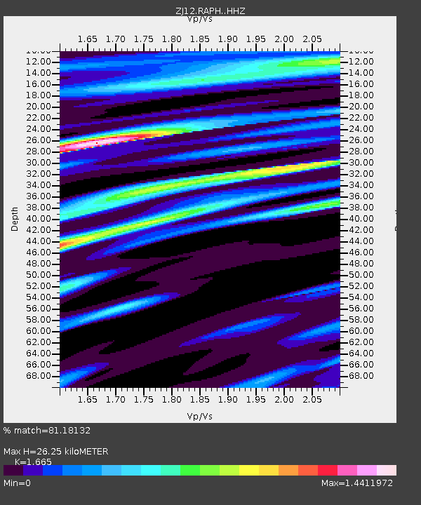
| Estimated Moho Depth: |
26.25 km |
| Estimated Crust Vp/Vs: |
1.66 |
| Assumed Crust Vp: |
6.264 km/s |
| Estimated Crust Vs: |
3.762 km/s |
| Estimated Crust Poisson's Ratio: |
0.22 |
|
| Radial Match: |
81.18132 % |
| Radial Bump: |
400 |
| Transverse Match: |
66.22955 % |
| Transverse Bump: |
400 |
| SOD ConfigId: |
3390531 |
| Insert Time: |
2019-04-14 04:13:43.937 +0000 |
| GWidth: |
2.5 |
| Max Bumps: |
400 |
| Tol: |
0.001 |
|

Signal To Noise
| Channel | StoN | STA | LTA |
| ZJ:RAPH: :HHZ:20140922T16:09:58.099011Z | 3.7116468 | 1.2415904E-6 | 3.34512E-7 |
| ZJ:RAPH: :HHN:20140922T16:09:58.099011Z | 2.746067 | 6.4118825E-7 | 2.3349331E-7 |
| ZJ:RAPH: :HHE:20140922T16:09:58.099011Z | 0.7782986 | 1.7758371E-7 | 2.2816913E-7 |
| Arrivals |
| Ps | 3.0 SECOND |
| PpPs | 11 SECOND |
| PsPs/PpSs | 13 SECOND |


