You are here: Home > Network List > TA - USArray Transportable Network (new EarthScope stations) Stations List
> Station R54A Victor, WV, USA > Earthquake Result Viewer
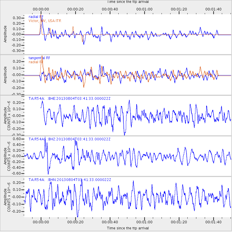
R54A Victor, WV, USA - Earthquake Result Viewer
*The percent match for this event was below the threshold and hence no stack was calculated.
| Earthquake location: |
Near East Coast Of Honshu, Japan |
| Earthquake latitude/longitude: |
38.2/141.9 |
| Earthquake time(UTC): |
2013/08/04 (216) 03:28:50 GMT |
| Earthquake Depth: |
56 km |
| Earthquake Magnitude: |
5.8 MW, 5.8 MB, 5.9 MW |
| Earthquake Catalog/Contributor: |
NEIC PDE/NEIC PDE-W |
|
| Network: |
TA USArray Transportable Network (new EarthScope stations) |
| Station: |
R54A Victor, WV, USA |
| Lat/Lon: |
38.18 N/80.99 W |
| Elevation: |
512 m |
|
| Distance: |
94.4 deg |
| Az: |
32.516 deg |
| Baz: |
327.5 deg |
| Ray Param: |
$rayparam |
*The percent match for this event was below the threshold and hence was not used in the summary stack. |
|
| Radial Match: |
66.50691 % |
| Radial Bump: |
400 |
| Transverse Match: |
63.599537 % |
| Transverse Bump: |
400 |
| SOD ConfigId: |
589702 |
| Insert Time: |
2013-09-25 00:11:36.749 +0000 |
| GWidth: |
2.5 |
| Max Bumps: |
400 |
| Tol: |
0.001 |
|
Signal To Noise
| Channel | StoN | STA | LTA |
| TA:R54A: :BHZ:20130804T03:41:33.000022Z | 3.2252347 | 3.058754E-7 | 9.4838185E-8 |
| TA:R54A: :BHN:20130804T03:41:33.000022Z | 1.0644082 | 1.0031998E-7 | 9.4249536E-8 |
| TA:R54A: :BHE:20130804T03:41:33.000022Z | 1.2250484 | 1.015382E-7 | 8.2885045E-8 |
| Arrivals |
| Ps | |
| PpPs | |
| PsPs/PpSs | |


