You are here: Home > Network List > TA - USArray Transportable Network (new EarthScope stations) Stations List
> Station S49A Springfield, KY, USA > Earthquake Result Viewer
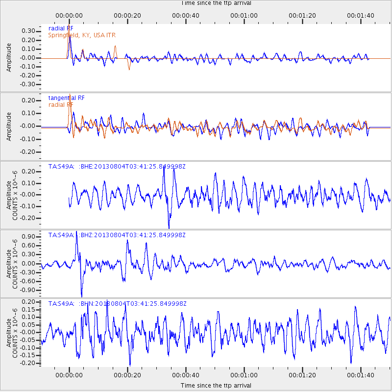
S49A Springfield, KY, USA - Earthquake Result Viewer
*The percent match for this event was below the threshold and hence no stack was calculated.
| Earthquake location: |
Near East Coast Of Honshu, Japan |
| Earthquake latitude/longitude: |
38.2/141.9 |
| Earthquake time(UTC): |
2013/08/04 (216) 03:28:50 GMT |
| Earthquake Depth: |
56 km |
| Earthquake Magnitude: |
5.8 MW, 5.8 MB, 5.9 MW |
| Earthquake Catalog/Contributor: |
NEIC PDE/NEIC PDE-W |
|
| Network: |
TA USArray Transportable Network (new EarthScope stations) |
| Station: |
S49A Springfield, KY, USA |
| Lat/Lon: |
37.78 N/85.29 W |
| Elevation: |
230 m |
|
| Distance: |
92.8 deg |
| Az: |
35.56 deg |
| Baz: |
324.676 deg |
| Ray Param: |
$rayparam |
*The percent match for this event was below the threshold and hence was not used in the summary stack. |
|
| Radial Match: |
60.99565 % |
| Radial Bump: |
400 |
| Transverse Match: |
54.058636 % |
| Transverse Bump: |
400 |
| SOD ConfigId: |
589702 |
| Insert Time: |
2013-09-25 00:11:58.531 +0000 |
| GWidth: |
2.5 |
| Max Bumps: |
400 |
| Tol: |
0.001 |
|
Signal To Noise
| Channel | StoN | STA | LTA |
| TA:S49A: :BHZ:20130804T03:41:25.849998Z | 4.88376 | 4.5471035E-7 | 9.3106614E-8 |
| TA:S49A: :BHN:20130804T03:41:25.849998Z | 1.3040631 | 7.4114006E-8 | 5.6833144E-8 |
| TA:S49A: :BHE:20130804T03:41:25.849998Z | 1.8921909 | 1.150369E-7 | 6.079561E-8 |
| Arrivals |
| Ps | |
| PpPs | |
| PsPs/PpSs | |


