You are here: Home > Network List > TA - USArray Transportable Network (new EarthScope stations) Stations List
> Station U40A Yellville, AR, USA > Earthquake Result Viewer
U40A Yellville, AR, USA - Earthquake Result Viewer
| Earthquake location: |
Near East Coast Of Honshu, Japan |
| Earthquake latitude/longitude: |
38.2/141.9 |
| Earthquake time(UTC): |
2013/08/04 (216) 03:28:50 GMT |
| Earthquake Depth: |
56 km |
| Earthquake Magnitude: |
5.8 MW, 5.8 MB, 5.9 MW |
| Earthquake Catalog/Contributor: |
NEIC PDE/NEIC PDE-W |
|
| Network: |
TA USArray Transportable Network (new EarthScope stations) |
| Station: |
U40A Yellville, AR, USA |
| Lat/Lon: |
36.36 N/92.85 W |
| Elevation: |
374 m |
|
| Distance: |
90.2 deg |
| Az: |
41.22 deg |
| Baz: |
319.982 deg |
| Ray Param: |
0.041680194 |
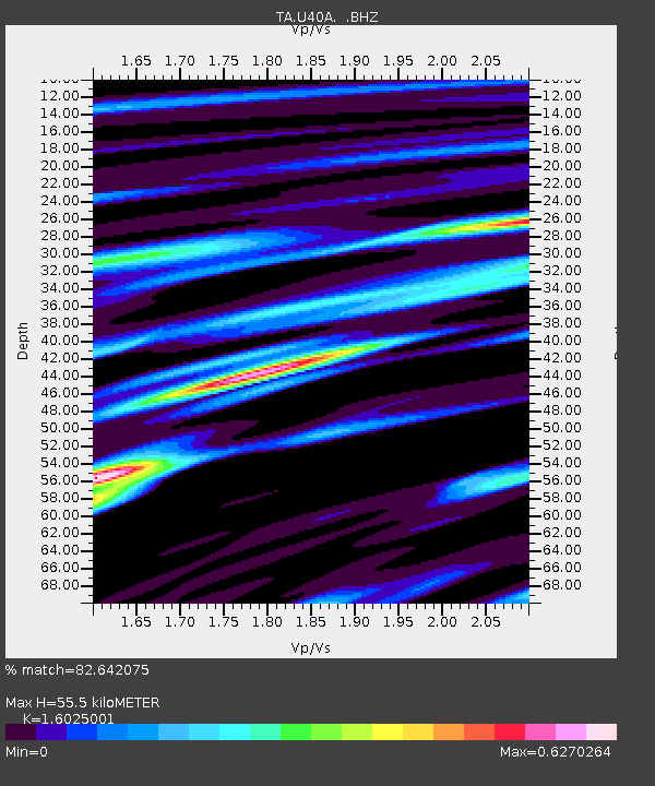
| Estimated Moho Depth: |
55.5 km |
| Estimated Crust Vp/Vs: |
1.60 |
| Assumed Crust Vp: |
6.53 km/s |
| Estimated Crust Vs: |
4.075 km/s |
| Estimated Crust Poisson's Ratio: |
0.18 |
|
| Radial Match: |
82.642075 % |
| Radial Bump: |
400 |
| Transverse Match: |
81.583755 % |
| Transverse Bump: |
400 |
| SOD ConfigId: |
589702 |
| Insert Time: |
2013-09-25 00:13:05.632 +0000 |
| GWidth: |
2.5 |
| Max Bumps: |
400 |
| Tol: |
0.001 |
|

Signal To Noise
| Channel | StoN | STA | LTA |
| TA:U40A: :BHZ:20130804T03:41:13.974998Z | 9.568885 | 6.707206E-7 | 7.009392E-8 |
| TA:U40A: :BHN:20130804T03:41:13.974998Z | 5.6866126 | 2.178543E-7 | 3.831003E-8 |
| TA:U40A: :BHE:20130804T03:41:13.974998Z | 4.253714 | 1.5553832E-7 | 3.6565297E-8 |
| Arrivals |
| Ps | 5.2 SECOND |
| PpPs | 22 SECOND |
| PsPs/PpSs | 27 SECOND |


