You are here: Home > Network List > IU - Global Seismograph Network (GSN - IRIS/USGS) Stations List
> Station JOHN Johnston Island, USA > Earthquake Result Viewer
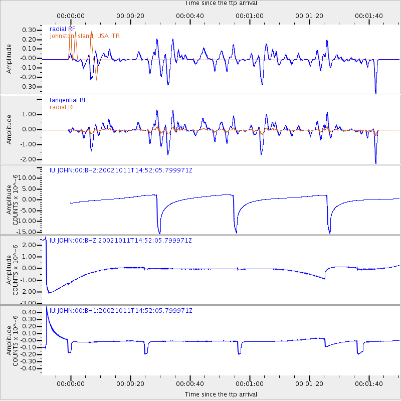
JOHN Johnston Island, USA - Earthquake Result Viewer
*The percent match for this event was below the threshold and hence no stack was calculated.
| Earthquake location: |
Near Coast Of Oaxaca, Mexico |
| Earthquake latitude/longitude: |
15.7/-95.7 |
| Earthquake time(UTC): |
2002/10/11 (284) 14:41:25 GMT |
| Earthquake Depth: |
33 km |
| Earthquake Magnitude: |
5.5 MW |
| Earthquake Catalog/Contributor: |
NEIC PDE/NEIC PDE-M |
|
| Network: |
IU Global Seismograph Network (GSN - IRIS/USGS) |
| Station: |
JOHN Johnston Island, USA |
| Lat/Lon: |
16.73 N/169.53 W |
| Elevation: |
2.0 m |
|
| Distance: |
70.5 deg |
| Az: |
282.499 deg |
| Baz: |
78.961 deg |
| Ray Param: |
$rayparam |
*The percent match for this event was below the threshold and hence was not used in the summary stack. |
|
| Radial Match: |
59.180588 % |
| Radial Bump: |
400 |
| Transverse Match: |
60.111145 % |
| Transverse Bump: |
400 |
| SOD ConfigId: |
590571 |
| Insert Time: |
2013-09-25 00:13:15.708 +0000 |
| GWidth: |
2.5 |
| Max Bumps: |
400 |
| Tol: |
0.001 |
|
Signal To Noise
| Channel | StoN | STA | LTA |
| IU:JOHN:00:BHZ:20021011T14:52:05.799971Z | 1.3222828 | 1.7150912E-6 | 1.2970684E-6 |
| IU:JOHN:00:BH1:20021011T14:52:05.799971Z | 0.56223845 | 6.112879E-8 | 1.08723945E-7 |
| IU:JOHN:00:BH2:20021011T14:52:05.799971Z | 7.631177 | 7.2701273E-6 | 9.5268757E-7 |
| Arrivals |
| Ps | |
| PpPs | |
| PsPs/PpSs | |


