You are here: Home > Network List > GS - US Geological Survey Networks Stations List
> Station KAN13 Rinehart Farm > Earthquake Result Viewer
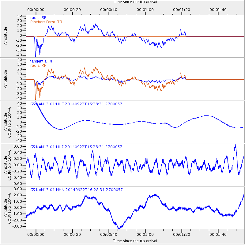
KAN13 Rinehart Farm - Earthquake Result Viewer
*The percent match for this event was below the threshold and hence no stack was calculated.
| Earthquake location: |
Tonga Islands |
| Earthquake latitude/longitude: |
-20.4/-174.1 |
| Earthquake time(UTC): |
2014/09/22 (265) 16:15:56 GMT |
| Earthquake Depth: |
27 km |
| Earthquake Magnitude: |
4.8 mb |
| Earthquake Catalog/Contributor: |
ISC/ISC |
|
| Network: |
GS US Geological Survey Networks |
| Station: |
KAN13 Rinehart Farm |
| Lat/Lon: |
37.01 N/97.48 W |
| Elevation: |
340 m |
|
| Distance: |
91.9 deg |
| Az: |
51.176 deg |
| Baz: |
245.953 deg |
| Ray Param: |
$rayparam |
*The percent match for this event was below the threshold and hence was not used in the summary stack. |
|
| Radial Match: |
63.89387 % |
| Radial Bump: |
400 |
| Transverse Match: |
64.07216 % |
| Transverse Bump: |
400 |
| SOD ConfigId: |
3390531 |
| Insert Time: |
2019-04-14 04:16:42.908 +0000 |
| GWidth: |
2.5 |
| Max Bumps: |
400 |
| Tol: |
0.001 |
|
Signal To Noise
| Channel | StoN | STA | LTA |
| GS:KAN13:01:HHZ:20140922T16:28:31.270005Z | 1.2053471 | 2.4123554E-7 | 2.0013782E-7 |
| GS:KAN13:01:HHN:20140922T16:28:31.270005Z | 0.3119423 | 1.0670719E-6 | 3.420735E-6 |
| GS:KAN13:01:HHE:20140922T16:28:31.270005Z | 0.15464096 | 2.353606E-6 | 1.521981E-5 |
| Arrivals |
| Ps | |
| PpPs | |
| PsPs/PpSs | |


