You are here: Home > Network List > IU - Global Seismograph Network (GSN - IRIS/USGS) Stations List
> Station RSSD Black Hills, South Dakota, USA > Earthquake Result Viewer
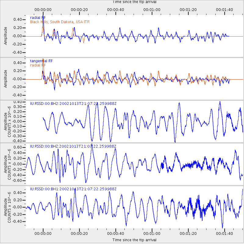
RSSD Black Hills, South Dakota, USA - Earthquake Result Viewer
*The percent match for this event was below the threshold and hence no stack was calculated.
| Earthquake location: |
Samoa Islands Region |
| Earthquake latitude/longitude: |
-14.6/-175.4 |
| Earthquake time(UTC): |
2002/10/13 (286) 20:55:07 GMT |
| Earthquake Depth: |
10 km |
| Earthquake Magnitude: |
5.8 MB, 6.0 MS, 6.1 MW, 6.0 MW |
| Earthquake Catalog/Contributor: |
WHDF/NEIC |
|
| Network: |
IU Global Seismograph Network (GSN - IRIS/USGS) |
| Station: |
RSSD Black Hills, South Dakota, USA |
| Lat/Lon: |
44.12 N/104.04 W |
| Elevation: |
2060 m |
|
| Distance: |
87.2 deg |
| Az: |
43.104 deg |
| Baz: |
246.716 deg |
| Ray Param: |
$rayparam |
*The percent match for this event was below the threshold and hence was not used in the summary stack. |
|
| Radial Match: |
76.97335 % |
| Radial Bump: |
400 |
| Transverse Match: |
65.938 % |
| Transverse Bump: |
400 |
| SOD ConfigId: |
590571 |
| Insert Time: |
2013-09-25 00:15:05.223 +0000 |
| GWidth: |
2.5 |
| Max Bumps: |
400 |
| Tol: |
0.001 |
|
Signal To Noise
| Channel | StoN | STA | LTA |
| IU:RSSD:00:BHZ:20021013T21:07:22.259988Z | 0.8746741 | 1.5565617E-7 | 1.7795904E-7 |
| IU:RSSD:00:BH1:20021013T21:07:22.259988Z | 0.8247308 | 8.071331E-8 | 9.786625E-8 |
| IU:RSSD:00:BH2:20021013T21:07:22.259988Z | 2.4886537 | 2.7832868E-7 | 1.1183906E-7 |
| Arrivals |
| Ps | |
| PpPs | |
| PsPs/PpSs | |


