You are here: Home > Network List > TJ - Tajikistan National Seismic Network Stations List
> Station GARM Garm, Tajikistan > Earthquake Result Viewer
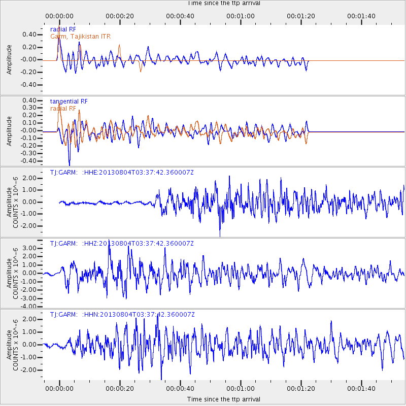
GARM Garm, Tajikistan - Earthquake Result Viewer
*The percent match for this event was below the threshold and hence no stack was calculated.
| Earthquake location: |
Near East Coast Of Honshu, Japan |
| Earthquake latitude/longitude: |
38.2/141.9 |
| Earthquake time(UTC): |
2013/08/04 (216) 03:28:50 GMT |
| Earthquake Depth: |
56 km |
| Earthquake Magnitude: |
5.8 MW, 5.8 MB, 5.9 MW |
| Earthquake Catalog/Contributor: |
NEIC PDE/NEIC PDE-W |
|
| Network: |
TJ Tajikistan National Seismic Network |
| Station: |
GARM Garm, Tajikistan |
| Lat/Lon: |
39.00 N/70.32 E |
| Elevation: |
1305 m |
|
| Distance: |
54.5 deg |
| Az: |
294.816 deg |
| Baz: |
66.576 deg |
| Ray Param: |
$rayparam |
*The percent match for this event was below the threshold and hence was not used in the summary stack. |
|
| Radial Match: |
78.536476 % |
| Radial Bump: |
400 |
| Transverse Match: |
82.80668 % |
| Transverse Bump: |
400 |
| SOD ConfigId: |
589702 |
| Insert Time: |
2013-09-25 00:15:31.691 +0000 |
| GWidth: |
2.5 |
| Max Bumps: |
400 |
| Tol: |
0.001 |
|
Signal To Noise
| Channel | StoN | STA | LTA |
| TJ:GARM: :HHZ:20130804T03:37:42.360007Z | 7.403697 | 9.1032445E-7 | 1.2295538E-7 |
| TJ:GARM: :HHN:20130804T03:37:42.360007Z | 2.4716778 | 2.5315094E-7 | 1.02420685E-7 |
| TJ:GARM: :HHE:20130804T03:37:42.360007Z | 6.503944 | 4.6268536E-7 | 7.11392E-8 |
| Arrivals |
| Ps | |
| PpPs | |
| PsPs/PpSs | |


