You are here: Home > Network List > US - United States National Seismic Network Stations List
> Station AMTX Amarillo, Texas, USA > Earthquake Result Viewer
AMTX Amarillo, Texas, USA - Earthquake Result Viewer
*The percent match for this event was below the threshold and hence no stack was calculated.
| Earthquake location: |
Near East Coast Of Honshu, Japan |
| Earthquake latitude/longitude: |
38.2/141.9 |
| Earthquake time(UTC): |
2013/08/04 (216) 03:28:50 GMT |
| Earthquake Depth: |
56 km |
| Earthquake Magnitude: |
5.8 MW, 5.8 MB, 5.9 MW |
| Earthquake Catalog/Contributor: |
NEIC PDE/NEIC PDE-W |
|
| Network: |
US United States National Seismic Network |
| Station: |
AMTX Amarillo, Texas, USA |
| Lat/Lon: |
34.53 N/101.41 W |
| Elevation: |
1010 m |
|
| Distance: |
86.8 deg |
| Az: |
47.604 deg |
| Baz: |
315.201 deg |
| Ray Param: |
$rayparam |
*The percent match for this event was below the threshold and hence was not used in the summary stack. |
|
| Radial Match: |
75.03634 % |
| Radial Bump: |
400 |
| Transverse Match: |
73.55502 % |
| Transverse Bump: |
400 |
| SOD ConfigId: |
589702 |
| Insert Time: |
2013-09-25 00:15:58.200 +0000 |
| GWidth: |
2.5 |
| Max Bumps: |
400 |
| Tol: |
0.001 |
|
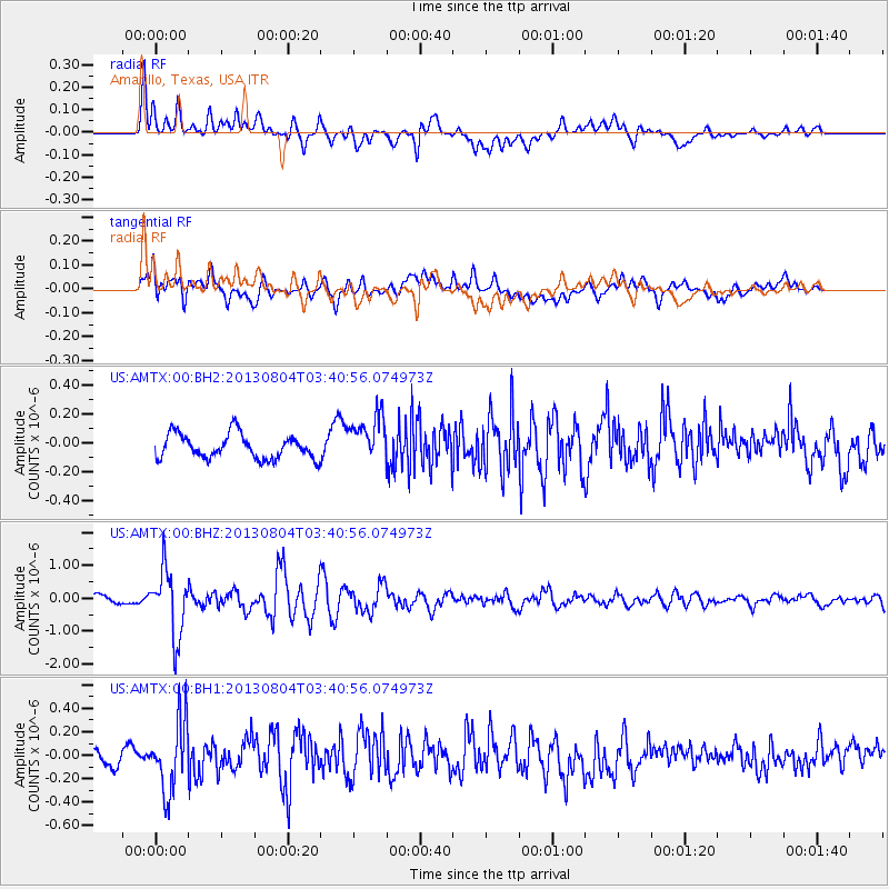
Signal To Noise
| Channel | StoN | STA | LTA |
| US:AMTX:00:BHZ:20130804T03:40:56.074973Z | 8.534322 | 9.944961E-7 | 1.16529016E-7 |
| US:AMTX:00:BH1:20130804T03:40:56.074973Z | 4.0684743 | 3.0110786E-7 | 7.401002E-8 |
| US:AMTX:00:BH2:20130804T03:40:56.074973Z | 2.0032969 | 1.7294971E-7 | 8.633254E-8 |
| Arrivals |
| Ps | |
| PpPs | |
| PsPs/PpSs | |


