You are here: Home > Network List > IU - Global Seismograph Network (GSN - IRIS/USGS) Stations List
> Station POHA Pohakuloa, Hawaii, USA > Earthquake Result Viewer
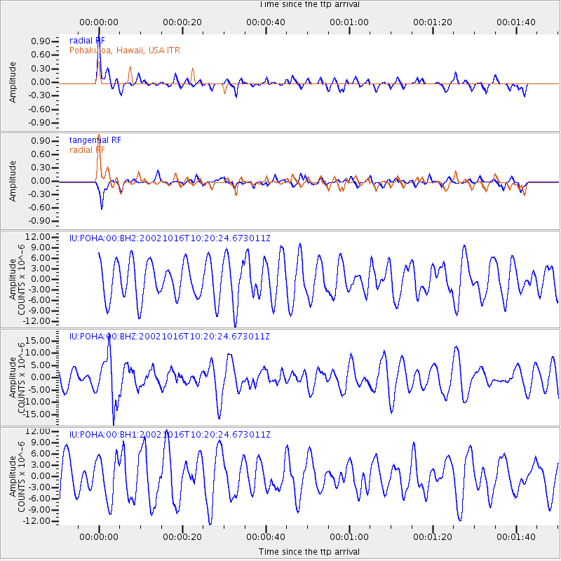
POHA Pohakuloa, Hawaii, USA - Earthquake Result Viewer
*The percent match for this event was below the threshold and hence no stack was calculated.
| Earthquake location: |
Near East Coast Of Kamchatka |
| Earthquake latitude/longitude: |
52.0/157.3 |
| Earthquake time(UTC): |
2002/10/16 (289) 10:12:21 GMT |
| Earthquake Depth: |
102 km |
| Earthquake Magnitude: |
6.1 MB, 6.2 MW, 6.2 MW |
| Earthquake Catalog/Contributor: |
WHDF/NEIC |
|
| Network: |
IU Global Seismograph Network (GSN - IRIS/USGS) |
| Station: |
POHA Pohakuloa, Hawaii, USA |
| Lat/Lon: |
19.76 N/155.53 W |
| Elevation: |
1967 m |
|
| Distance: |
48.7 deg |
| Az: |
113.15 deg |
| Baz: |
322.83 deg |
| Ray Param: |
$rayparam |
*The percent match for this event was below the threshold and hence was not used in the summary stack. |
|
| Radial Match: |
61.599205 % |
| Radial Bump: |
400 |
| Transverse Match: |
57.831017 % |
| Transverse Bump: |
393 |
| SOD ConfigId: |
590571 |
| Insert Time: |
2013-09-25 00:16:05.777 +0000 |
| GWidth: |
2.5 |
| Max Bumps: |
400 |
| Tol: |
0.001 |
|
Signal To Noise
| Channel | StoN | STA | LTA |
| IU:POHA:00:BHZ:20021016T10:20:24.673011Z | 3.1840708 | 9.613901E-6 | 3.0193744E-6 |
| IU:POHA:00:BH1:20021016T10:20:24.673011Z | 0.9675036 | 5.859335E-6 | 6.0561374E-6 |
| IU:POHA:00:BH2:20021016T10:20:24.673011Z | 1.3750887 | 6.8035047E-6 | 4.947684E-6 |
| Arrivals |
| Ps | |
| PpPs | |
| PsPs/PpSs | |


