You are here: Home > Network List > IU - Global Seismograph Network (GSN - IRIS/USGS) Stations List
> Station JOHN Johnston Island, USA > Earthquake Result Viewer
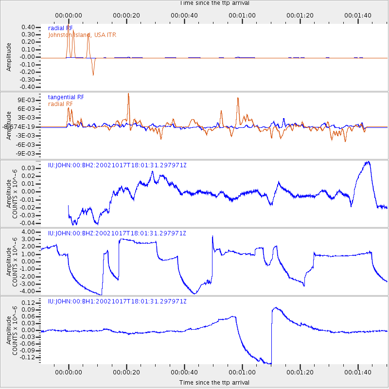
JOHN Johnston Island, USA - Earthquake Result Viewer
*The percent match for this event was below the threshold and hence no stack was calculated.
| Earthquake location: |
Irian Jaya, Indonesia |
| Earthquake latitude/longitude: |
-3.6/140.2 |
| Earthquake time(UTC): |
2002/10/17 (290) 17:52:44 GMT |
| Earthquake Depth: |
33 km |
| Earthquake Magnitude: |
5.6 MB, 6.2 MS, 6.3 MW, 6.3 MW |
| Earthquake Catalog/Contributor: |
WHDF/NEIC |
|
| Network: |
IU Global Seismograph Network (GSN - IRIS/USGS) |
| Station: |
JOHN Johnston Island, USA |
| Lat/Lon: |
16.73 N/169.53 W |
| Elevation: |
2.0 m |
|
| Distance: |
53.6 deg |
| Az: |
66.273 deg |
| Baz: |
252.471 deg |
| Ray Param: |
$rayparam |
*The percent match for this event was below the threshold and hence was not used in the summary stack. |
|
| Radial Match: |
66.462814 % |
| Radial Bump: |
378 |
| Transverse Match: |
52.56504 % |
| Transverse Bump: |
400 |
| SOD ConfigId: |
590571 |
| Insert Time: |
2013-09-25 00:17:22.887 +0000 |
| GWidth: |
2.5 |
| Max Bumps: |
400 |
| Tol: |
0.001 |
|
Signal To Noise
| Channel | StoN | STA | LTA |
| IU:JOHN:00:BHZ:20021017T18:01:31.297971Z | 1.4722772 | 2.5432598E-6 | 1.7274328E-6 |
| IU:JOHN:00:BH1:20021017T18:01:31.297971Z | 0.45292535 | 1.8612326E-9 | 4.1093586E-9 |
| IU:JOHN:00:BH2:20021017T18:01:31.297971Z | 2.1008847 | 3.387203E-8 | 1.6122744E-8 |
| Arrivals |
| Ps | |
| PpPs | |
| PsPs/PpSs | |


