You are here: Home > Network List > UU - University of Utah Regional Network Stations List
> Station SPU South Promontory Point, UT, USA > Earthquake Result Viewer
SPU South Promontory Point, UT, USA - Earthquake Result Viewer
| Earthquake location: |
Near East Coast Of Honshu, Japan |
| Earthquake latitude/longitude: |
38.2/141.9 |
| Earthquake time(UTC): |
2013/08/04 (216) 03:28:50 GMT |
| Earthquake Depth: |
56 km |
| Earthquake Magnitude: |
5.8 MW, 5.8 MB, 5.9 MW |
| Earthquake Catalog/Contributor: |
NEIC PDE/NEIC PDE-W |
|
| Network: |
UU University of Utah Regional Network |
| Station: |
SPU South Promontory Point, UT, USA |
| Lat/Lon: |
41.31 N/112.45 W |
| Elevation: |
2086 m |
|
| Distance: |
75.8 deg |
| Az: |
48.419 deg |
| Baz: |
308.542 deg |
| Ray Param: |
0.05128702 |
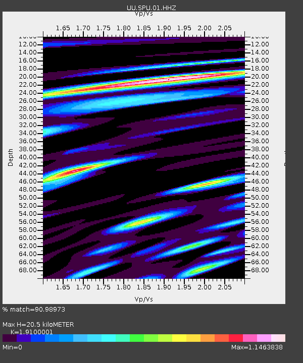
| Estimated Moho Depth: |
20.5 km |
| Estimated Crust Vp/Vs: |
1.91 |
| Assumed Crust Vp: |
6.276 km/s |
| Estimated Crust Vs: |
3.286 km/s |
| Estimated Crust Poisson's Ratio: |
0.31 |
|
| Radial Match: |
90.98973 % |
| Radial Bump: |
400 |
| Transverse Match: |
82.17858 % |
| Transverse Bump: |
400 |
| SOD ConfigId: |
589702 |
| Insert Time: |
2013-09-25 00:18:47.268 +0000 |
| GWidth: |
2.5 |
| Max Bumps: |
400 |
| Tol: |
0.001 |
|

Signal To Noise
| Channel | StoN | STA | LTA |
| UU:SPU:01:HHZ:20130804T03:40:00.079001Z | 6.0035725 | 1.4018016E-8 | 2.3349458E-9 |
| UU:SPU:01:HHN:20130804T03:40:00.079001Z | 5.129948 | 4.533106E-9 | 8.836553E-10 |
| UU:SPU:01:HHE:20130804T03:40:00.079001Z | 3.7249696 | 5.2315183E-9 | 1.4044459E-9 |
| Arrivals |
| Ps | 3.1 SECOND |
| PpPs | 9.2 SECOND |
| PsPs/PpSs | 12 SECOND |


