You are here: Home > Network List > IU - Global Seismograph Network (GSN - IRIS/USGS) Stations List
> Station JOHN Johnston Island, USA > Earthquake Result Viewer
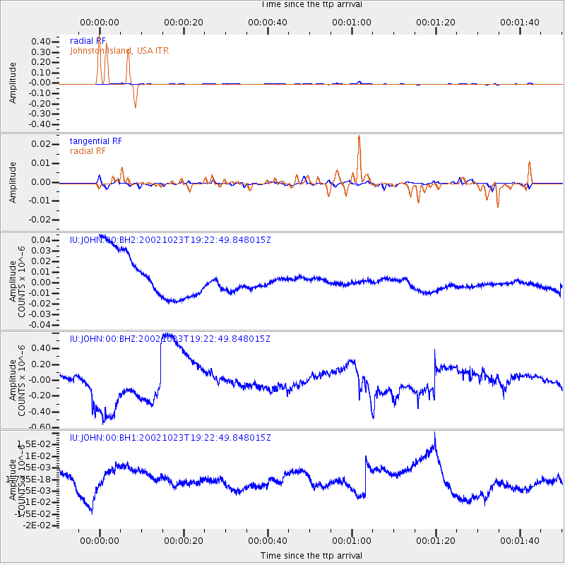
JOHN Johnston Island, USA - Earthquake Result Viewer
*The percent match for this event was below the threshold and hence no stack was calculated.
| Earthquake location: |
Kermadec Islands Region |
| Earthquake latitude/longitude: |
-31.0/-179.8 |
| Earthquake time(UTC): |
2002/10/23 (296) 19:15:13 GMT |
| Earthquake Depth: |
361 km |
| Earthquake Magnitude: |
5.8 MW |
| Earthquake Catalog/Contributor: |
NEIC PDE/NEIC PDE-M |
|
| Network: |
IU Global Seismograph Network (GSN - IRIS/USGS) |
| Station: |
JOHN Johnston Island, USA |
| Lat/Lon: |
16.73 N/169.53 W |
| Elevation: |
2.0 m |
|
| Distance: |
48.4 deg |
| Az: |
13.221 deg |
| Baz: |
191.831 deg |
| Ray Param: |
$rayparam |
*The percent match for this event was below the threshold and hence was not used in the summary stack. |
|
| Radial Match: |
53.93553 % |
| Radial Bump: |
302 |
| Transverse Match: |
59.34016 % |
| Transverse Bump: |
323 |
| SOD ConfigId: |
590571 |
| Insert Time: |
2013-09-25 00:20:37.703 +0000 |
| GWidth: |
2.5 |
| Max Bumps: |
400 |
| Tol: |
0.001 |
|
Signal To Noise
| Channel | StoN | STA | LTA |
| IU:JOHN:00:BHZ:20021023T19:22:49.848015Z | 1.5554214 | 3.047605E-7 | 1.9593438E-7 |
| IU:JOHN:00:BH1:20021023T19:22:49.848015Z | 0.6460687 | 6.567013E-9 | 1.0164573E-8 |
| IU:JOHN:00:BH2:20021023T19:22:49.848015Z | 0.58736336 | 1.2712647E-8 | 2.1643581E-8 |
| Arrivals |
| Ps | |
| PpPs | |
| PsPs/PpSs | |


