You are here: Home > Network List > WY - Yellowstone Wyoming Seismic Network Stations List
> Station YHH Holmes Hill, YNP, WY, USA > Earthquake Result Viewer
YHH Holmes Hill, YNP, WY, USA - Earthquake Result Viewer
| Earthquake location: |
Near East Coast Of Honshu, Japan |
| Earthquake latitude/longitude: |
38.2/141.9 |
| Earthquake time(UTC): |
2013/08/04 (216) 03:28:50 GMT |
| Earthquake Depth: |
56 km |
| Earthquake Magnitude: |
5.8 MW, 5.8 MB, 5.9 MW |
| Earthquake Catalog/Contributor: |
NEIC PDE/NEIC PDE-W |
|
| Network: |
WY Yellowstone Wyoming Seismic Network |
| Station: |
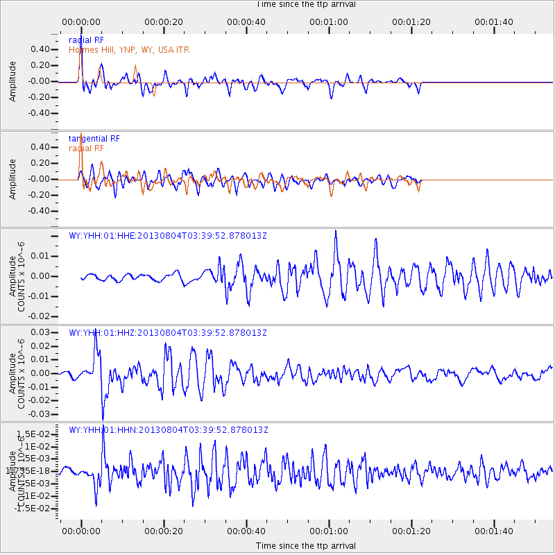
YHH Holmes Hill, YNP, WY, USA |
| Lat/Lon: |
44.79 N/110.85 W |
| Elevation: |
2717 m |
|
| Distance: |
74.6 deg |
| Az: |
44.852 deg |
| Baz: |
308.72 deg |
| Ray Param: |
0.052123405 |
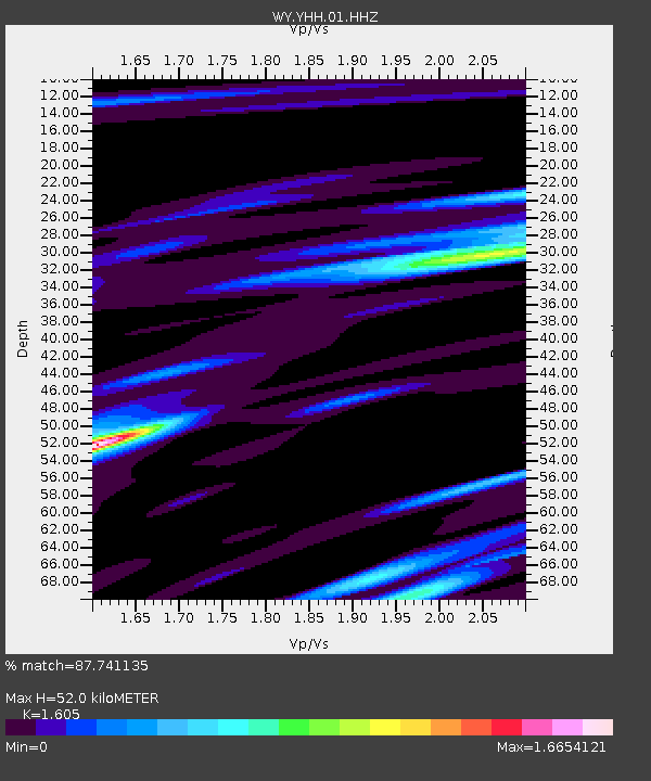
| Estimated Moho Depth: |
52.0 km |
| Estimated Crust Vp/Vs: |
1.61 |
| Assumed Crust Vp: |
6.35 km/s |
| Estimated Crust Vs: |
3.956 km/s |
| Estimated Crust Poisson's Ratio: |
0.18 |
|
| Radial Match: |
87.741135 % |
| Radial Bump: |
400 |
| Transverse Match: |
84.27665 % |
| Transverse Bump: |
400 |
| SOD ConfigId: |
589702 |
| Insert Time: |
2013-09-25 00:21:27.268 +0000 |
| GWidth: |
2.5 |
| Max Bumps: |
400 |
| Tol: |
0.001 |
|
Signal To Noise
| Channel | StoN | STA | LTA |
| WY:YHH:01:HHZ:20130804T03:39:52.878013Z | 7.597255 | 1.1710554E-8 | 1.541419E-9 |
| WY:YHH:01:HHN:20130804T03:39:52.878013Z | 5.028538 | 4.1218726E-9 | 8.196959E-10 |
| WY:YHH:01:HHE:20130804T03:39:52.878013Z | 2.4681146 | 3.713023E-9 | 1.5043964E-9 |
| Arrivals |
| Ps | 5.1 SECOND |
| PpPs | 21 SECOND |
| PsPs/PpSs | 26 SECOND |


