You are here: Home > Network List > IU - Global Seismograph Network (GSN - IRIS/USGS) Stations List
> Station RSSD Black Hills, South Dakota, USA > Earthquake Result Viewer
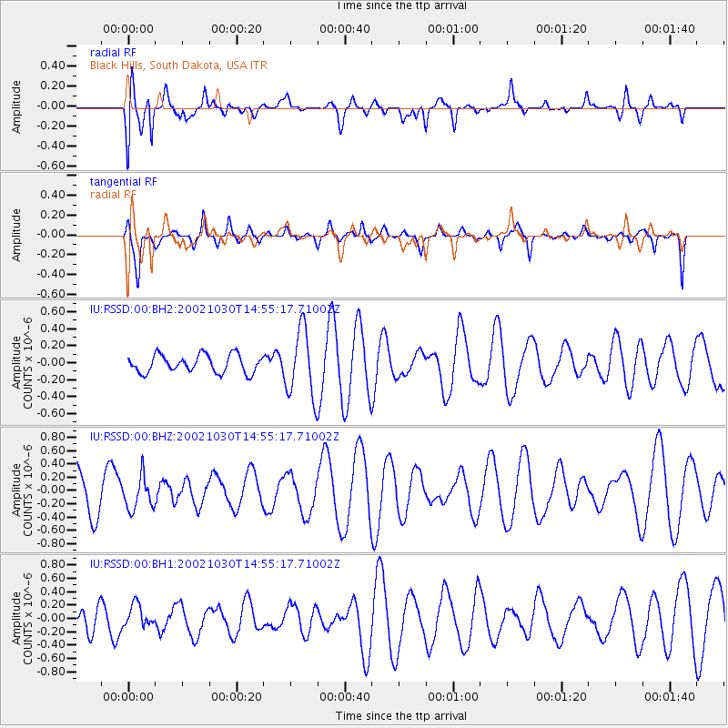
RSSD Black Hills, South Dakota, USA - Earthquake Result Viewer
*The percent match for this event was below the threshold and hence no stack was calculated.
| Earthquake location: |
Tonga Islands |
| Earthquake latitude/longitude: |
-17.6/-174.2 |
| Earthquake time(UTC): |
2002/10/30 (303) 14:43:05 GMT |
| Earthquake Depth: |
87 km |
| Earthquake Magnitude: |
5.5 MW |
| Earthquake Catalog/Contributor: |
NEIC PDE/NEIC PDE-M |
|
| Network: |
IU Global Seismograph Network (GSN - IRIS/USGS) |
| Station: |
RSSD Black Hills, South Dakota, USA |
| Lat/Lon: |
44.12 N/104.04 W |
| Elevation: |
2060 m |
|
| Distance: |
88.6 deg |
| Az: |
42.656 deg |
| Baz: |
243.807 deg |
| Ray Param: |
$rayparam |
*The percent match for this event was below the threshold and hence was not used in the summary stack. |
|
| Radial Match: |
61.768612 % |
| Radial Bump: |
400 |
| Transverse Match: |
52.89423 % |
| Transverse Bump: |
374 |
| SOD ConfigId: |
590571 |
| Insert Time: |
2013-09-25 00:22:53.423 +0000 |
| GWidth: |
2.5 |
| Max Bumps: |
400 |
| Tol: |
0.001 |
|
Signal To Noise
| Channel | StoN | STA | LTA |
| IU:RSSD:00:BHZ:20021030T14:55:17.71002Z | 1.0282803 | 2.4861075E-7 | 2.4177334E-7 |
| IU:RSSD:00:BH1:20021030T14:55:17.71002Z | 0.73386997 | 1.7134485E-7 | 2.3348122E-7 |
| IU:RSSD:00:BH2:20021030T14:55:17.71002Z | 3.8604114 | 4.0270837E-7 | 1.0431747E-7 |
| Arrivals |
| Ps | |
| PpPs | |
| PsPs/PpSs | |


