You are here: Home > Network List > IU - Global Seismograph Network (GSN - IRIS/USGS) Stations List
> Station JOHN Johnston Island, USA > Earthquake Result Viewer
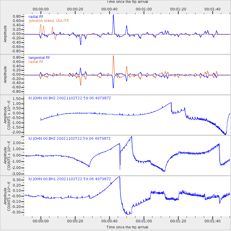
JOHN Johnston Island, USA - Earthquake Result Viewer
*The percent match for this event was below the threshold and hence no stack was calculated.
| Earthquake location: |
Central Alaska |
| Earthquake latitude/longitude: |
63.4/-145.1 |
| Earthquake time(UTC): |
2002/11/03 (307) 22:50:45 GMT |
| Earthquake Depth: |
5.0 km |
| Earthquake Magnitude: |
5.5 ML |
| Earthquake Catalog/Contributor: |
NEIC PDE/NEIC PDE-M |
|
| Network: |
IU Global Seismograph Network (GSN - IRIS/USGS) |
| Station: |
JOHN Johnston Island, USA |
| Lat/Lon: |
16.73 N/169.53 W |
| Elevation: |
2.0 m |
|
| Distance: |
49.6 deg |
| Az: |
211.397 deg |
| Baz: |
14.163 deg |
| Ray Param: |
$rayparam |
*The percent match for this event was below the threshold and hence was not used in the summary stack. |
|
| Radial Match: |
67.73639 % |
| Radial Bump: |
294 |
| Transverse Match: |
62.14385 % |
| Transverse Bump: |
299 |
| SOD ConfigId: |
590571 |
| Insert Time: |
2013-09-25 00:27:51.302 +0000 |
| GWidth: |
2.5 |
| Max Bumps: |
400 |
| Tol: |
0.001 |
|
Signal To Noise
| Channel | StoN | STA | LTA |
| IU:JOHN:00:BHZ:20021103T22:59:06.497987Z | 0.8008689 | 2.9770706E-7 | 3.7173007E-7 |
| IU:JOHN:00:BH1:20021103T22:59:06.497987Z | 0.8346667 | 1.6408624E-8 | 1.9658893E-8 |
| IU:JOHN:00:BH2:20021103T22:59:06.497987Z | 0.79880965 | 1.7520739E-7 | 2.1933559E-7 |
| Arrivals |
| Ps | |
| PpPs | |
| PsPs/PpSs | |


