You are here: Home > Network List > IU - Global Seismograph Network (GSN - IRIS/USGS) Stations List
> Station JOHN Johnston Island, USA > Earthquake Result Viewer
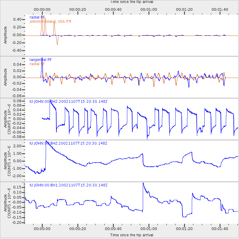
JOHN Johnston Island, USA - Earthquake Result Viewer
*The percent match for this event was below the threshold and hence no stack was calculated.
| Earthquake location: |
Rat Islands, Aleutian Islands |
| Earthquake latitude/longitude: |
51.2/179.3 |
| Earthquake time(UTC): |
2002/11/07 (311) 15:14:06 GMT |
| Earthquake Depth: |
33 km |
| Earthquake Magnitude: |
5.8 MB, 6.4 MS, 6.6 MW, 6.5 MW |
| Earthquake Catalog/Contributor: |
WHDF/NEIC |
|
| Network: |
IU Global Seismograph Network (GSN - IRIS/USGS) |
| Station: |
JOHN Johnston Island, USA |
| Lat/Lon: |
16.73 N/169.53 W |
| Elevation: |
2.0 m |
|
| Distance: |
35.5 deg |
| Az: |
161.423 deg |
| Baz: |
347.925 deg |
| Ray Param: |
$rayparam |
*The percent match for this event was below the threshold and hence was not used in the summary stack. |
|
| Radial Match: |
60.763218 % |
| Radial Bump: |
400 |
| Transverse Match: |
66.73651 % |
| Transverse Bump: |
400 |
| SOD ConfigId: |
590571 |
| Insert Time: |
2013-09-25 00:29:26.565 +0000 |
| GWidth: |
2.5 |
| Max Bumps: |
400 |
| Tol: |
0.001 |
|
Signal To Noise
| Channel | StoN | STA | LTA |
| IU:JOHN:00:BHZ:20021107T15:20:30.148Z | 5.506956 | 2.072856E-6 | 3.7640683E-7 |
| IU:JOHN:00:BH1:20021107T15:20:30.148Z | 1.1827168 | 4.124863E-8 | 3.4876162E-8 |
| IU:JOHN:00:BH2:20021107T15:20:30.148Z | 1.0538154 | 4.1498655E-8 | 3.9379437E-8 |
| Arrivals |
| Ps | |
| PpPs | |
| PsPs/PpSs | |


