You are here: Home > Network List > TA - USArray Transportable Network (new EarthScope stations) Stations List
> Station 149A Jones, AL, USA > Earthquake Result Viewer
149A Jones, AL, USA - Earthquake Result Viewer
| Earthquake location: |
Vancouver Island, Canada Region |
| Earthquake latitude/longitude: |
49.7/-127.4 |
| Earthquake time(UTC): |
2013/08/04 (216) 13:22:27 GMT |
| Earthquake Depth: |
10 km |
| Earthquake Magnitude: |
5.6 MB, 5.5 MW |
| Earthquake Catalog/Contributor: |
NEIC PDE/NEIC PDE-W |
|
| Network: |
TA USArray Transportable Network (new EarthScope stations) |
| Station: |
149A Jones, AL, USA |
| Lat/Lon: |
32.60 N/86.79 W |
| Elevation: |
138 m |
|
| Distance: |
34.5 deg |
| Az: |
104.135 deg |
| Baz: |
311.708 deg |
| Ray Param: |
0.07769177 |
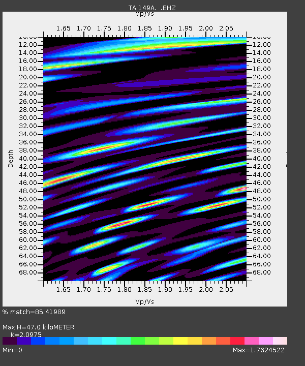
| Estimated Moho Depth: |
47.0 km |
| Estimated Crust Vp/Vs: |
2.10 |
| Assumed Crust Vp: |
6.565 km/s |
| Estimated Crust Vs: |
3.13 km/s |
| Estimated Crust Poisson's Ratio: |
0.35 |
|
| Radial Match: |
85.41989 % |
| Radial Bump: |
400 |
| Transverse Match: |
75.35895 % |
| Transverse Bump: |
400 |
| SOD ConfigId: |
589702 |
| Insert Time: |
2013-09-25 00:32:52.558 +0000 |
| GWidth: |
2.5 |
| Max Bumps: |
400 |
| Tol: |
0.001 |
|

Signal To Noise
| Channel | StoN | STA | LTA |
| TA:149A: :BHZ:20130804T13:28:45.324998Z | 13.099324 | 6.5589956E-7 | 5.007125E-8 |
| TA:149A: :BHN:20130804T13:28:45.324998Z | 7.5905747 | 5.8968624E-7 | 7.7686636E-8 |
| TA:149A: :BHE:20130804T13:28:45.324998Z | 11.956985 | 8.59243E-7 | 7.186118E-8 |
| Arrivals |
| Ps | 8.4 SECOND |
| PpPs | 21 SECOND |
| PsPs/PpSs | 29 SECOND |


