You are here: Home > Network List > IU - Global Seismograph Network (GSN - IRIS/USGS) Stations List
> Station JOHN Johnston Island, USA > Earthquake Result Viewer
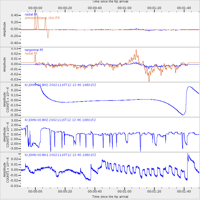
JOHN Johnston Island, USA - Earthquake Result Viewer
*The percent match for this event was below the threshold and hence no stack was calculated.
| Earthquake location: |
Kuril Islands |
| Earthquake latitude/longitude: |
50.4/156.6 |
| Earthquake time(UTC): |
2002/11/16 (320) 12:06:25 GMT |
| Earthquake Depth: |
96 km |
| Earthquake Magnitude: |
5.6 MW, 5.5 MW |
| Earthquake Catalog/Contributor: |
NEIC PDE/NEIC PDE-M |
|
| Network: |
IU Global Seismograph Network (GSN - IRIS/USGS) |
| Station: |
JOHN Johnston Island, USA |
| Lat/Lon: |
16.73 N/169.53 W |
| Elevation: |
2.0 m |
|
| Distance: |
43.2 deg |
| Az: |
128.658 deg |
| Baz: |
328.546 deg |
| Ray Param: |
$rayparam |
*The percent match for this event was below the threshold and hence was not used in the summary stack. |
|
| Radial Match: |
67.89521 % |
| Radial Bump: |
400 |
| Transverse Match: |
72.43276 % |
| Transverse Bump: |
400 |
| SOD ConfigId: |
590571 |
| Insert Time: |
2013-09-25 00:34:44.031 +0000 |
| GWidth: |
2.5 |
| Max Bumps: |
400 |
| Tol: |
0.001 |
|
Signal To Noise
| Channel | StoN | STA | LTA |
| IU:JOHN:00:BHZ:20021116T12:13:46.198015Z | 1.6603682 | 2.2248162E-6 | 1.3399534E-6 |
| IU:JOHN:00:BH1:20021116T12:13:46.198015Z | 1.1051395 | 3.2180185E-9 | 2.9118663E-9 |
| IU:JOHN:00:BH2:20021116T12:13:46.198015Z | 0.64404285 | 8.018143E-8 | 1.2449705E-7 |
| Arrivals |
| Ps | |
| PpPs | |
| PsPs/PpSs | |


