You are here: Home > Network List > IU - Global Seismograph Network (GSN - IRIS/USGS) Stations List
> Station RSSD Black Hills, South Dakota, USA > Earthquake Result Viewer
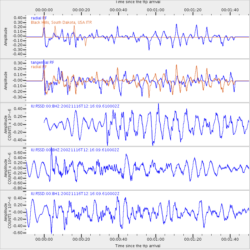
RSSD Black Hills, South Dakota, USA - Earthquake Result Viewer
*The percent match for this event was below the threshold and hence no stack was calculated.
| Earthquake location: |
Kuril Islands |
| Earthquake latitude/longitude: |
50.4/156.6 |
| Earthquake time(UTC): |
2002/11/16 (320) 12:06:25 GMT |
| Earthquake Depth: |
96 km |
| Earthquake Magnitude: |
5.6 MW, 5.5 MW |
| Earthquake Catalog/Contributor: |
NEIC PDE/NEIC PDE-M |
|
| Network: |
IU Global Seismograph Network (GSN - IRIS/USGS) |
| Station: |
RSSD Black Hills, South Dakota, USA |
| Lat/Lon: |
44.12 N/104.04 W |
| Elevation: |
2060 m |
|
| Distance: |
62.8 deg |
| Az: |
53.043 deg |
| Baz: |
314.73 deg |
| Ray Param: |
$rayparam |
*The percent match for this event was below the threshold and hence was not used in the summary stack. |
|
| Radial Match: |
49.507618 % |
| Radial Bump: |
400 |
| Transverse Match: |
53.599834 % |
| Transverse Bump: |
400 |
| SOD ConfigId: |
590571 |
| Insert Time: |
2013-09-25 00:34:49.437 +0000 |
| GWidth: |
2.5 |
| Max Bumps: |
400 |
| Tol: |
0.001 |
|
Signal To Noise
| Channel | StoN | STA | LTA |
| IU:RSSD:00:BHZ:20021116T12:16:09.610002Z | 2.0355735 | 3.3544055E-7 | 1.647892E-7 |
| IU:RSSD:00:BH1:20021116T12:16:09.610002Z | 1.4505875 | 2.1527386E-7 | 1.484046E-7 |
| IU:RSSD:00:BH2:20021116T12:16:09.610002Z | 1.2602038 | 1.8972523E-7 | 1.5055122E-7 |
| Arrivals |
| Ps | |
| PpPs | |
| PsPs/PpSs | |


