You are here: Home > Network List > TA - USArray Transportable Network (new EarthScope stations) Stations List
> Station L50A Kingsville, ON, CAN > Earthquake Result Viewer
L50A Kingsville, ON, CAN - Earthquake Result Viewer
| Earthquake location: |
Vancouver Island, Canada Region |
| Earthquake latitude/longitude: |
49.7/-127.4 |
| Earthquake time(UTC): |
2013/08/04 (216) 13:22:27 GMT |
| Earthquake Depth: |
10 km |
| Earthquake Magnitude: |
5.6 MB, 5.5 MW |
| Earthquake Catalog/Contributor: |
NEIC PDE/NEIC PDE-W |
|
| Network: |
TA USArray Transportable Network (new EarthScope stations) |
| Station: |
L50A Kingsville, ON, CAN |
| Lat/Lon: |
42.04 N/82.81 W |
| Elevation: |
187 m |
|
| Distance: |
31.6 deg |
| Az: |
86.654 deg |
| Baz: |
299.434 deg |
| Ray Param: |
0.07900514 |
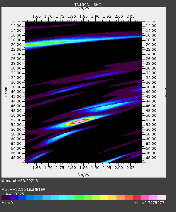
| Estimated Moho Depth: |
52.25 km |
| Estimated Crust Vp/Vs: |
1.83 |
| Assumed Crust Vp: |
6.483 km/s |
| Estimated Crust Vs: |
3.538 km/s |
| Estimated Crust Poisson's Ratio: |
0.29 |
|
| Radial Match: |
83.20218 % |
| Radial Bump: |
400 |
| Transverse Match: |
65.78881 % |
| Transverse Bump: |
400 |
| SOD ConfigId: |
589702 |
| Insert Time: |
2013-09-25 00:36:30.362 +0000 |
| GWidth: |
2.5 |
| Max Bumps: |
400 |
| Tol: |
0.001 |
|
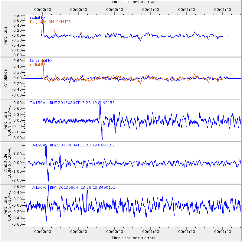
Signal To Noise
| Channel | StoN | STA | LTA |
| TA:L50A: :BHZ:20130804T13:28:19.849015Z | 6.979905 | 8.743592E-7 | 1.2526806E-7 |
| TA:L50A: :BHN:20130804T13:28:19.849015Z | 2.956066 | 2.2383126E-7 | 7.5719306E-8 |
| TA:L50A: :BHE:20130804T13:28:19.849015Z | 6.6507015 | 4.0887423E-7 | 6.147836E-8 |
| Arrivals |
| Ps | 7.3 SECOND |
| PpPs | 21 SECOND |
| PsPs/PpSs | 28 SECOND |


