You are here: Home > Network List > TA - USArray Transportable Network (new EarthScope stations) Stations List
> Station N49A Columbus Grove, OH, USA > Earthquake Result Viewer
N49A Columbus Grove, OH, USA - Earthquake Result Viewer
| Earthquake location: |
Vancouver Island, Canada Region |
| Earthquake latitude/longitude: |
49.7/-127.4 |
| Earthquake time(UTC): |
2013/08/04 (216) 13:22:27 GMT |
| Earthquake Depth: |
10 km |
| Earthquake Magnitude: |
5.6 MB, 5.5 MW |
| Earthquake Catalog/Contributor: |
NEIC PDE/NEIC PDE-W |
|
| Network: |
TA USArray Transportable Network (new EarthScope stations) |
| Station: |
N49A Columbus Grove, OH, USA |
| Lat/Lon: |
40.92 N/84.18 W |
| Elevation: |
225 m |
|
| Distance: |
31.3 deg |
| Az: |
89.505 deg |
| Baz: |
300.96 deg |
| Ray Param: |
0.07911123 |
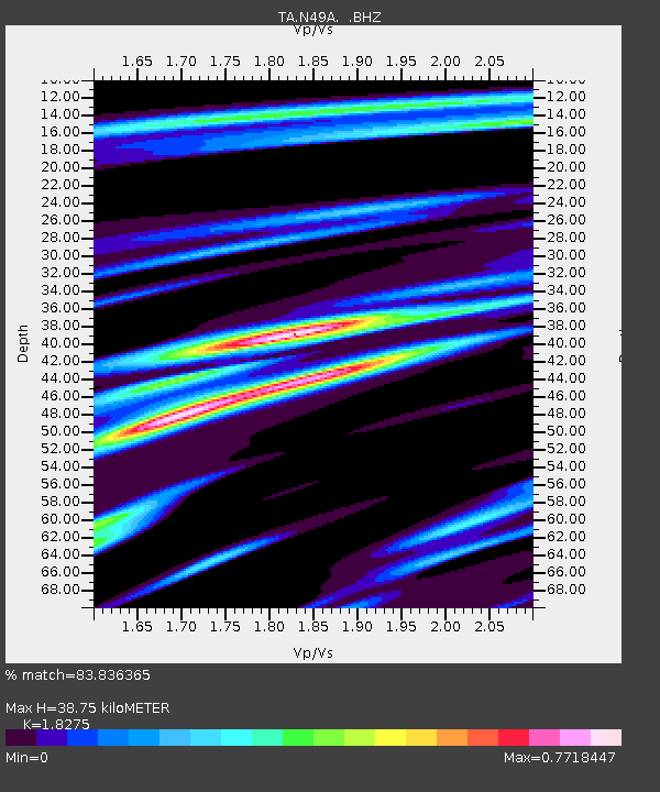
| Estimated Moho Depth: |
38.75 km |
| Estimated Crust Vp/Vs: |
1.83 |
| Assumed Crust Vp: |
6.498 km/s |
| Estimated Crust Vs: |
3.555 km/s |
| Estimated Crust Poisson's Ratio: |
0.29 |
|
| Radial Match: |
83.836365 % |
| Radial Bump: |
345 |
| Transverse Match: |
70.06383 % |
| Transverse Bump: |
400 |
| SOD ConfigId: |
589702 |
| Insert Time: |
2013-09-25 00:37:19.554 +0000 |
| GWidth: |
2.5 |
| Max Bumps: |
400 |
| Tol: |
0.001 |
|

Signal To Noise
| Channel | StoN | STA | LTA |
| TA:N49A: :BHZ:20130804T13:28:16.949998Z | 10.906653 | 7.85865E-7 | 7.205372E-8 |
| TA:N49A: :BHN:20130804T13:28:16.949998Z | 7.080932 | 3.089455E-7 | 4.3630624E-8 |
| TA:N49A: :BHE:20130804T13:28:16.949998Z | 7.609601 | 4.3232407E-7 | 5.6812976E-8 |
| Arrivals |
| Ps | 5.3 SECOND |
| PpPs | 16 SECOND |
| PsPs/PpSs | 21 SECOND |


