You are here: Home > Network List > TA - USArray Transportable Network (new EarthScope stations) Stations List
> Station R53A Hurricane, WV, USA > Earthquake Result Viewer
R53A Hurricane, WV, USA - Earthquake Result Viewer
*The percent match for this event was below the threshold and hence no stack was calculated.
| Earthquake location: |
Vancouver Island, Canada Region |
| Earthquake latitude/longitude: |
49.7/-127.4 |
| Earthquake time(UTC): |
2013/08/04 (216) 13:22:27 GMT |
| Earthquake Depth: |
10 km |
| Earthquake Magnitude: |
5.6 MB, 5.5 MW |
| Earthquake Catalog/Contributor: |
NEIC PDE/NEIC PDE-W |
|
| Network: |
TA USArray Transportable Network (new EarthScope stations) |
| Station: |
R53A Hurricane, WV, USA |
| Lat/Lon: |
38.33 N/81.95 W |
| Elevation: |
294 m |
|
| Distance: |
34.1 deg |
| Az: |
91.817 deg |
| Baz: |
304.325 deg |
| Ray Param: |
$rayparam |
*The percent match for this event was below the threshold and hence was not used in the summary stack. |
|
| Radial Match: |
65.13745 % |
| Radial Bump: |
400 |
| Transverse Match: |
56.50163 % |
| Transverse Bump: |
400 |
| SOD ConfigId: |
589702 |
| Insert Time: |
2013-09-25 00:39:35.488 +0000 |
| GWidth: |
2.5 |
| Max Bumps: |
400 |
| Tol: |
0.001 |
|
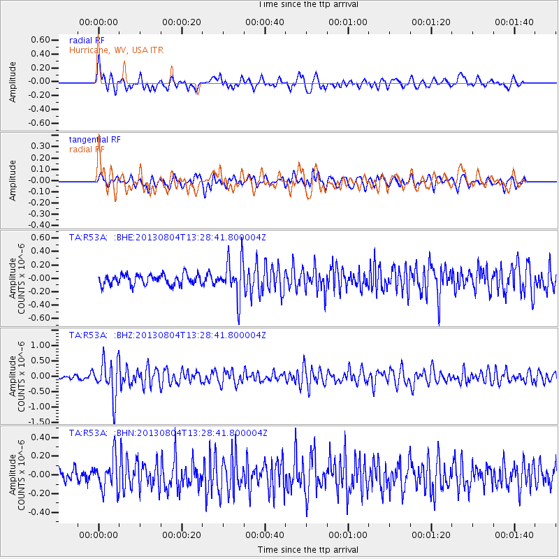
Signal To Noise
| Channel | StoN | STA | LTA |
| TA:R53A: :BHZ:20130804T13:28:41.800004Z | 6.9351487 | 6.0752467E-7 | 8.760082E-8 |
| TA:R53A: :BHN:20130804T13:28:41.800004Z | 2.995349 | 1.7529158E-7 | 5.8521255E-8 |
| TA:R53A: :BHE:20130804T13:28:41.800004Z | 3.7525616 | 2.8996308E-7 | 7.7270705E-8 |
| Arrivals |
| Ps | |
| PpPs | |
| PsPs/PpSs | |


