You are here: Home > Network List > TA - USArray Transportable Network (new EarthScope stations) Stations List
> Station S50A Richmond, KY, USA > Earthquake Result Viewer
S50A Richmond, KY, USA - Earthquake Result Viewer
| Earthquake location: |
Vancouver Island, Canada Region |
| Earthquake latitude/longitude: |
49.7/-127.4 |
| Earthquake time(UTC): |
2013/08/04 (216) 13:22:27 GMT |
| Earthquake Depth: |
10 km |
| Earthquake Magnitude: |
5.6 MB, 5.5 MW |
| Earthquake Catalog/Contributor: |
NEIC PDE/NEIC PDE-W |
|
| Network: |
TA USArray Transportable Network (new EarthScope stations) |
| Station: |
S50A Richmond, KY, USA |
| Lat/Lon: |
37.68 N/84.40 W |
| Elevation: |
300 m |
|
| Distance: |
32.9 deg |
| Az: |
94.785 deg |
| Baz: |
305.297 deg |
| Ray Param: |
0.07845147 |
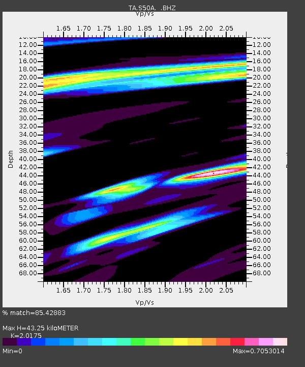
| Estimated Moho Depth: |
43.25 km |
| Estimated Crust Vp/Vs: |
2.02 |
| Assumed Crust Vp: |
6.476 km/s |
| Estimated Crust Vs: |
3.21 km/s |
| Estimated Crust Poisson's Ratio: |
0.34 |
|
| Radial Match: |
85.42883 % |
| Radial Bump: |
400 |
| Transverse Match: |
66.47154 % |
| Transverse Bump: |
400 |
| SOD ConfigId: |
589702 |
| Insert Time: |
2013-09-25 00:39:59.642 +0000 |
| GWidth: |
2.5 |
| Max Bumps: |
400 |
| Tol: |
0.001 |
|

Signal To Noise
| Channel | StoN | STA | LTA |
| TA:S50A: :BHZ:20130804T13:28:31.224991Z | 13.009442 | 1.0228516E-6 | 7.862379E-8 |
| TA:S50A: :BHN:20130804T13:28:31.224991Z | 6.008551 | 3.192017E-7 | 5.312457E-8 |
| TA:S50A: :BHE:20130804T13:28:31.224991Z | 6.641279 | 3.785456E-7 | 5.69989E-8 |
| Arrivals |
| Ps | 7.3 SECOND |
| PpPs | 19 SECOND |
| PsPs/PpSs | 26 SECOND |


