You are here: Home > Network List > CN - Canadian National Seismograph Network Stations List
> Station ULM LAC DU BONNET, MB, CANADA > Earthquake Result Viewer
ULM LAC DU BONNET, MB, CANADA - Earthquake Result Viewer
| Earthquake location: |
Pakistan |
| Earthquake latitude/longitude: |
34.5/73.6 |
| Earthquake time(UTC): |
2005/10/08 (281) 03:50:40 GMT |
| Earthquake Depth: |
26 km |
| Earthquake Magnitude: |
6.9 MB, 7.7 MS, 7.6 MW, 7.3 MW |
| Earthquake Catalog/Contributor: |
WHDF/NEIC |
|
| Network: |
CN Canadian National Seismograph Network |
| Station: |
ULM LAC DU BONNET, MB, CANADA |
| Lat/Lon: |
50.25 N/95.87 W |
| Elevation: |
251 m |
|
| Distance: |
95.1 deg |
| Az: |
353.231 deg |
| Baz: |
8.717 deg |
| Ray Param: |
0.040871475 |
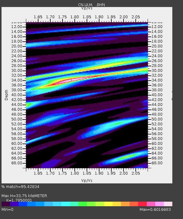
| Estimated Moho Depth: |
33.75 km |
| Estimated Crust Vp/Vs: |
1.79 |
| Assumed Crust Vp: |
6.459 km/s |
| Estimated Crust Vs: |
3.619 km/s |
| Estimated Crust Poisson's Ratio: |
0.27 |
|
| Radial Match: |
95.42834 % |
| Radial Bump: |
327 |
| Transverse Match: |
75.63796 % |
| Transverse Bump: |
400 |
| SOD ConfigId: |
2564 |
| Insert Time: |
2010-02-27 07:32:04.555 +0000 |
| GWidth: |
2.5 |
| Max Bumps: |
400 |
| Tol: |
0.001 |
|
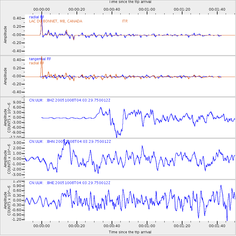
Signal To Noise
| Channel | StoN | STA | LTA |
| CN:ULM: :BHN:20051008T04:03:29.750012Z | 4.410782 | 1.0700134E-6 | 2.425904E-7 |
| CN:ULM: :BHE:20051008T04:03:29.750012Z | 1.7571217 | 2.1800909E-7 | 1.2407172E-7 |
| CN:ULM: :BHZ:20051008T04:03:29.750012Z | 15.848477 | 3.1971795E-6 | 2.0173417E-7 |
| Arrivals |
| Ps | 4.2 SECOND |
| PpPs | 14 SECOND |
| PsPs/PpSs | 18 SECOND |


