You are here: Home > Network List > CN - Canadian National Seismograph Network Stations List
> Station ULM LAC DU BONNET, MB, CANADA > Earthquake Result Viewer
ULM LAC DU BONNET, MB, CANADA - Earthquake Result Viewer
| Earthquake location: |
Northern Peru |
| Earthquake latitude/longitude: |
-5.7/-76.4 |
| Earthquake time(UTC): |
2005/09/26 (269) 01:55:37 GMT |
| Earthquake Depth: |
115 km |
| Earthquake Magnitude: |
6.7 MB, 7.5 MW, 7.5 MW |
| Earthquake Catalog/Contributor: |
WHDF/NEIC |
|
| Network: |
CN Canadian National Seismograph Network |
| Station: |
ULM LAC DU BONNET, MB, CANADA |
| Lat/Lon: |
50.25 N/95.87 W |
| Elevation: |
251 m |
|
| Distance: |
58.2 deg |
| Az: |
345.413 deg |
| Baz: |
157.02 deg |
| Ray Param: |
0.06265534 |
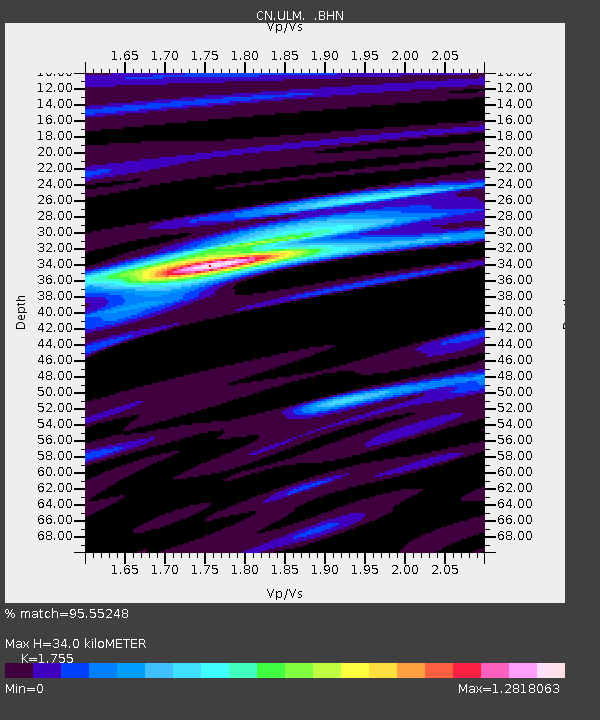
| Estimated Moho Depth: |
34.0 km |
| Estimated Crust Vp/Vs: |
1.75 |
| Assumed Crust Vp: |
6.459 km/s |
| Estimated Crust Vs: |
3.681 km/s |
| Estimated Crust Poisson's Ratio: |
0.26 |
|
| Radial Match: |
95.55248 % |
| Radial Bump: |
397 |
| Transverse Match: |
82.05033 % |
| Transverse Bump: |
400 |
| SOD ConfigId: |
2564 |
| Insert Time: |
2010-02-27 07:32:07.175 +0000 |
| GWidth: |
2.5 |
| Max Bumps: |
400 |
| Tol: |
0.001 |
|
Signal To Noise
| Channel | StoN | STA | LTA |
| CN:ULM: :BHN:20050926T02:04:49.075029Z | 37.854862 | 1.1513009E-5 | 3.0413554E-7 |
| CN:ULM: :BHE:20050926T02:04:49.075029Z | 28.019897 | 4.490021E-6 | 1.6024403E-7 |
| CN:ULM: :BHZ:20050926T02:04:49.075029Z | 77.402466 | 2.5704308E-5 | 3.3208644E-7 |
| Arrivals |
| Ps | 4.2 SECOND |
| PpPs | 14 SECOND |
| PsPs/PpSs | 18 SECOND |


