You are here: Home > Network List > CN - Canadian National Seismograph Network Stations List
> Station ULM LAC DU BONNET, MB, CANADA > Earthquake Result Viewer
ULM LAC DU BONNET, MB, CANADA - Earthquake Result Viewer
| Earthquake location: |
Southern Greece |
| Earthquake latitude/longitude: |
38.0/21.5 |
| Earthquake time(UTC): |
2008/06/08 (160) 12:25:29 GMT |
| Earthquake Depth: |
16 km |
| Earthquake Magnitude: |
6.2 MB, 6.3 MS, 6.3 MW, 6.3 MW |
| Earthquake Catalog/Contributor: |
WHDF/NEIC |
|
| Network: |
CN Canadian National Seismograph Network |
| Station: |
ULM LAC DU BONNET, MB, CANADA |
| Lat/Lon: |
50.25 N/95.87 W |
| Elevation: |
251 m |
|
| Distance: |
76.3 deg |
| Az: |
324.088 deg |
| Baz: |
46.233 deg |
| Ray Param: |
0.05104923 |
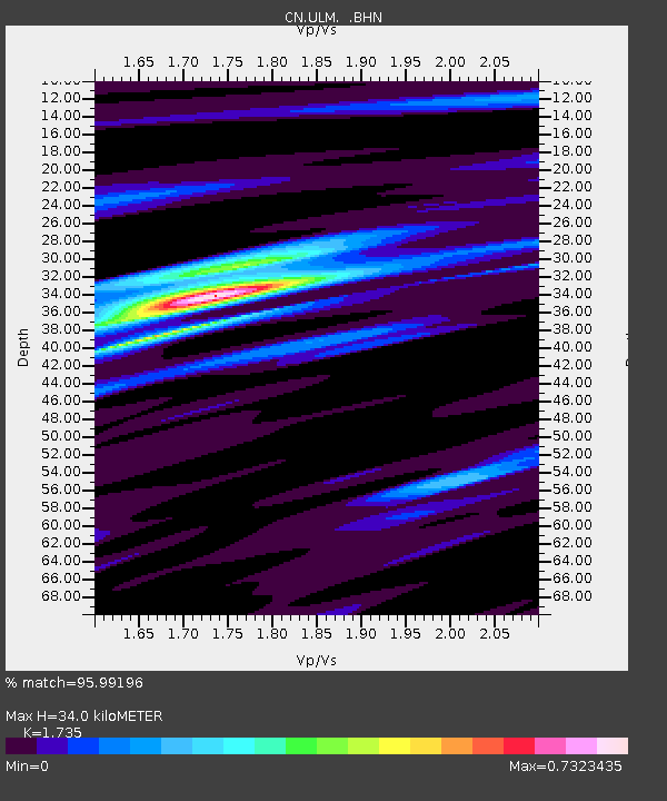
| Estimated Moho Depth: |
34.0 km |
| Estimated Crust Vp/Vs: |
1.74 |
| Assumed Crust Vp: |
6.459 km/s |
| Estimated Crust Vs: |
3.723 km/s |
| Estimated Crust Poisson's Ratio: |
0.25 |
|
| Radial Match: |
95.99196 % |
| Radial Bump: |
287 |
| Transverse Match: |
79.9337 % |
| Transverse Bump: |
400 |
| SOD ConfigId: |
2504 |
| Insert Time: |
2010-02-27 07:32:19.134 +0000 |
| GWidth: |
2.5 |
| Max Bumps: |
400 |
| Tol: |
0.001 |
|
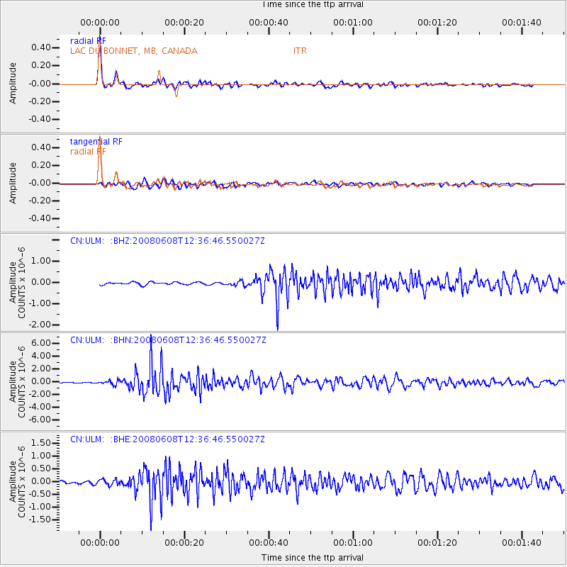
Signal To Noise
| Channel | StoN | STA | LTA |
| CN:ULM: :BHN:20080608T12:36:46.550027Z | 3.3846781 | 3.0315587E-7 | 8.9567116E-8 |
| CN:ULM: :BHE:20080608T12:36:46.550027Z | 2.337356 | 1.1020729E-7 | 4.71504E-8 |
| CN:ULM: :BHZ:20080608T12:36:46.550027Z | 1.7787375 | 1.0623474E-7 | 5.972479E-8 |
| Arrivals |
| Ps | 4.0 SECOND |
| PpPs | 14 SECOND |
| PsPs/PpSs | 18 SECOND |


