You are here: Home > Network List > CN - Canadian National Seismograph Network Stations List
> Station ULM LAC DU BONNET, MB, CANADA > Earthquake Result Viewer
ULM LAC DU BONNET, MB, CANADA - Earthquake Result Viewer
| Earthquake location: |
Dodecanese Islands, Greece |
| Earthquake latitude/longitude: |
35.8/27.9 |
| Earthquake time(UTC): |
2008/07/15 (197) 03:26:34 GMT |
| Earthquake Depth: |
52 km |
| Earthquake Magnitude: |
6.5 MB, 6.4 MW, 6.4 MW |
| Earthquake Catalog/Contributor: |
WHDF/NEIC |
|
| Network: |
CN Canadian National Seismograph Network |
| Station: |
ULM LAC DU BONNET, MB, CANADA |
| Lat/Lon: |
50.25 N/95.87 W |
| Elevation: |
251 m |
|
| Distance: |
81.0 deg |
| Az: |
327.279 deg |
| Baz: |
43.196 deg |
| Ray Param: |
0.04781015 |
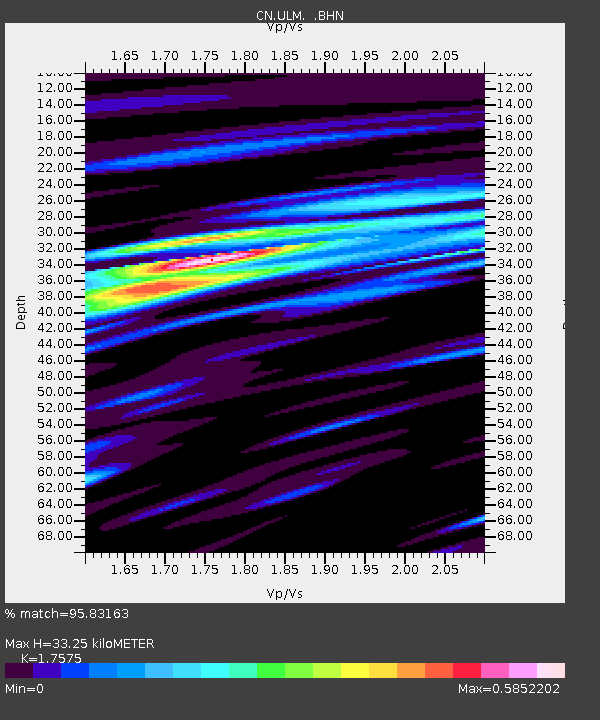
| Estimated Moho Depth: |
33.25 km |
| Estimated Crust Vp/Vs: |
1.76 |
| Assumed Crust Vp: |
6.459 km/s |
| Estimated Crust Vs: |
3.675 km/s |
| Estimated Crust Poisson's Ratio: |
0.26 |
|
| Radial Match: |
95.83163 % |
| Radial Bump: |
400 |
| Transverse Match: |
84.674095 % |
| Transverse Bump: |
400 |
| SOD ConfigId: |
2504 |
| Insert Time: |
2010-02-27 07:32:26.523 +0000 |
| GWidth: |
2.5 |
| Max Bumps: |
400 |
| Tol: |
0.001 |
|
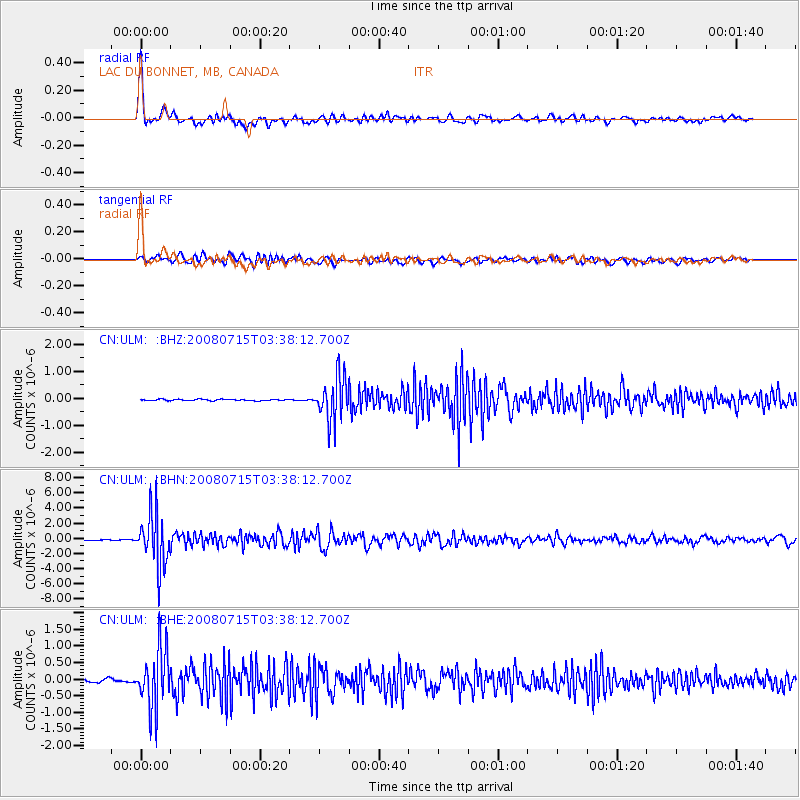
Signal To Noise
| Channel | StoN | STA | LTA |
| CN:ULM: :BHN:20080715T03:38:12.700Z | 94.3172 | 3.4539228E-6 | 3.6620285E-8 |
| CN:ULM: :BHE:20080715T03:38:12.700Z | 19.857111 | 8.7907245E-7 | 4.4269907E-8 |
| CN:ULM: :BHZ:20080715T03:38:12.700Z | 30.839834 | 8.010193E-7 | 2.5973529E-8 |
| Arrivals |
| Ps | 4.0 SECOND |
| PpPs | 14 SECOND |
| PsPs/PpSs | 18 SECOND |


