You are here: Home > Network List > IU - Global Seismograph Network (GSN - IRIS/USGS) Stations List
> Station RSSD Black Hills, South Dakota, USA > Earthquake Result Viewer
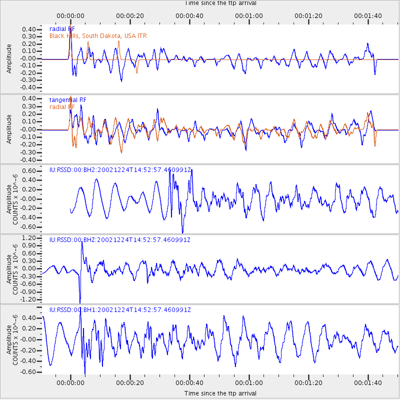
RSSD Black Hills, South Dakota, USA - Earthquake Result Viewer
*The percent match for this event was below the threshold and hence no stack was calculated.
| Earthquake location: |
Kuril Islands |
| Earthquake latitude/longitude: |
50.0/156.2 |
| Earthquake time(UTC): |
2002/12/24 (358) 14:43:07 GMT |
| Earthquake Depth: |
67 km |
| Earthquake Magnitude: |
5.5 MB, 5.5 MW, 5.4 MW |
| Earthquake Catalog/Contributor: |
WHDF/NEIC |
|
| Network: |
IU Global Seismograph Network (GSN - IRIS/USGS) |
| Station: |
RSSD Black Hills, South Dakota, USA |
| Lat/Lon: |
44.12 N/104.04 W |
| Elevation: |
2060 m |
|
| Distance: |
63.2 deg |
| Az: |
52.668 deg |
| Baz: |
314.574 deg |
| Ray Param: |
$rayparam |
*The percent match for this event was below the threshold and hence was not used in the summary stack. |
|
| Radial Match: |
60.617043 % |
| Radial Bump: |
400 |
| Transverse Match: |
62.241478 % |
| Transverse Bump: |
400 |
| SOD ConfigId: |
590571 |
| Insert Time: |
2013-09-25 00:51:17.716 +0000 |
| GWidth: |
2.5 |
| Max Bumps: |
400 |
| Tol: |
0.001 |
|
Signal To Noise
| Channel | StoN | STA | LTA |
| IU:RSSD:00:BHZ:20021224T14:52:57.460991Z | 3.009832 | 4.5186175E-7 | 1.5012856E-7 |
| IU:RSSD:00:BH1:20021224T14:52:57.460991Z | 1.1179907 | 2.5738763E-7 | 2.302234E-7 |
| IU:RSSD:00:BH2:20021224T14:52:57.460991Z | 1.5595384 | 3.3561005E-7 | 2.1519833E-7 |
| Arrivals |
| Ps | |
| PpPs | |
| PsPs/PpSs | |


