You are here: Home > Network List > IU - Global Seismograph Network (GSN - IRIS/USGS) Stations List
> Station JOHN Johnston Island, USA > Earthquake Result Viewer
JOHN Johnston Island, USA - Earthquake Result Viewer
*The percent match for this event was below the threshold and hence no stack was calculated.
| Earthquake location: |
Fiji Islands Region |
| Earthquake latitude/longitude: |
-17.7/-178.9 |
| Earthquake time(UTC): |
2002/12/25 (359) 08:54:25 GMT |
| Earthquake Depth: |
568 km |
| Earthquake Magnitude: |
5.5 MW |
| Earthquake Catalog/Contributor: |
NEIC PDE/NEIC PDE-M |
|
| Network: |
IU Global Seismograph Network (GSN - IRIS/USGS) |
| Station: |
JOHN Johnston Island, USA |
| Lat/Lon: |
16.73 N/169.53 W |
| Elevation: |
2.0 m |
|
| Distance: |
35.5 deg |
| Az: |
15.59 deg |
| Baz: |
195.504 deg |
| Ray Param: |
$rayparam |
*The percent match for this event was below the threshold and hence was not used in the summary stack. |
|
| Radial Match: |
66.638954 % |
| Radial Bump: |
400 |
| Transverse Match: |
59.33742 % |
| Transverse Bump: |
357 |
| SOD ConfigId: |
590571 |
| Insert Time: |
2013-09-25 00:51:42.049 +0000 |
| GWidth: |
2.5 |
| Max Bumps: |
400 |
| Tol: |
0.001 |
|
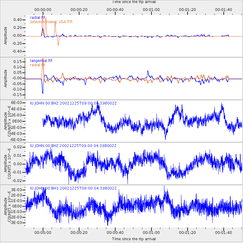
Signal To Noise
| Channel | StoN | STA | LTA |
| IU:JOHN:00:BHZ:20021225T09:00:04.398002Z | 2.264517 | 1.5562598E-8 | 6.87237E-9 |
| IU:JOHN:00:BH1:20021225T09:00:04.398002Z | 1.7260624 | 1.6359671E-9 | 9.478031E-10 |
| IU:JOHN:00:BH2:20021225T09:00:04.398002Z | 2.4335942 | 2.9409526E-9 | 1.208481E-9 |
| Arrivals |
| Ps | |
| PpPs | |
| PsPs/PpSs | |


