You are here: Home > Network List > IU - Global Seismograph Network (GSN - IRIS/USGS) Stations List
> Station JOHN Johnston Island, USA > Earthquake Result Viewer
JOHN Johnston Island, USA - Earthquake Result Viewer
| Earthquake location: |
Sumbawa Region, Indonesia |
| Earthquake latitude/longitude: |
-8.7/117.8 |
| Earthquake time(UTC): |
2003/01/03 (003) 01:34:13 GMT |
| Earthquake Depth: |
41 km |
| Earthquake Magnitude: |
5.5 MW |
| Earthquake Catalog/Contributor: |
NEIC PDE/NEIC PDE-M |
|
| Network: |
IU Global Seismograph Network (GSN - IRIS/USGS) |
| Station: |
JOHN Johnston Island, USA |
| Lat/Lon: |
16.73 N/169.53 W |
| Elevation: |
2.0 m |
|
| Distance: |
76.2 deg |
| Az: |
70.388 deg |
| Baz: |
256.363 deg |
| Ray Param: |
0.051092815 |
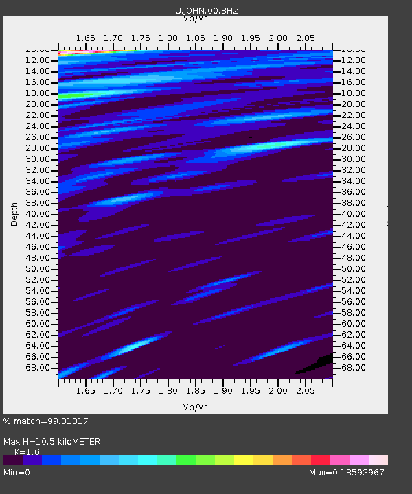
| Estimated Moho Depth: |
10.5 km |
| Estimated Crust Vp/Vs: |
1.60 |
| Assumed Crust Vp: |
4.24 km/s |
| Estimated Crust Vs: |
2.65 km/s |
| Estimated Crust Poisson's Ratio: |
0.18 |
|
| Radial Match: |
99.01817 % |
| Radial Bump: |
151 |
| Transverse Match: |
99.78739 % |
| Transverse Bump: |
70 |
| SOD ConfigId: |
590571 |
| Insert Time: |
2013-09-25 00:54:55.656 +0000 |
| GWidth: |
2.5 |
| Max Bumps: |
400 |
| Tol: |
0.001 |
|

Signal To Noise
| Channel | StoN | STA | LTA |
| IU:JOHN:00:BHZ:20030103T01:45:26.339971Z | 7.184606 | 6.0767555E-8 | 8.458021E-9 |
| IU:JOHN:00:BH1:20030103T01:45:26.339971Z | 8.293639 | 1.9875001E-8 | 2.396415E-9 |
| IU:JOHN:00:BH2:20030103T01:45:26.339971Z | 9.695441 | 2.4410603E-8 | 2.5177402E-9 |
| Arrivals |
| Ps | 1.5 SECOND |
| PpPs | 6.3 SECOND |
| PsPs/PpSs | 7.9 SECOND |


