You are here: Home > Network List > IU - Global Seismograph Network (GSN - IRIS/USGS) Stations List
> Station JOHN Johnston Island, USA > Earthquake Result Viewer
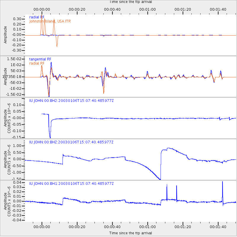
JOHN Johnston Island, USA - Earthquake Result Viewer
*The percent match for this event was below the threshold and hence no stack was calculated.
| Earthquake location: |
Philippine Islands Region |
| Earthquake latitude/longitude: |
20.1/121.5 |
| Earthquake time(UTC): |
2003/01/06 (006) 14:57:33 GMT |
| Earthquake Depth: |
33 km |
| Earthquake Magnitude: |
5.6 MW, 5.6 MW, 5.6 MB |
| Earthquake Catalog/Contributor: |
NEIC PDE/NEIC PDE-M |
|
| Network: |
IU Global Seismograph Network (GSN - IRIS/USGS) |
| Station: |
JOHN Johnston Island, USA |
| Lat/Lon: |
16.73 N/169.53 W |
| Elevation: |
2.0 m |
|
| Distance: |
65.1 deg |
| Az: |
80.386 deg |
| Baz: |
284.737 deg |
| Ray Param: |
$rayparam |
*The percent match for this event was below the threshold and hence was not used in the summary stack. |
|
| Radial Match: |
23.127178 % |
| Radial Bump: |
363 |
| Transverse Match: |
17.589437 % |
| Transverse Bump: |
372 |
| SOD ConfigId: |
590571 |
| Insert Time: |
2013-09-25 00:55:52.698 +0000 |
| GWidth: |
2.5 |
| Max Bumps: |
400 |
| Tol: |
0.001 |
|
Signal To Noise
| Channel | StoN | STA | LTA |
| IU:JOHN:00:BHZ:20030106T15:07:40.485977Z | 1.437922 | 3.0859553E-7 | 2.1461214E-7 |
| IU:JOHN:00:BH1:20030106T15:07:40.485977Z | 3.167728 | 2.9647698E-9 | 9.359294E-10 |
| IU:JOHN:00:BH2:20030106T15:07:40.485977Z | 0.0455362 | 1.3524353E-9 | 2.9700223E-8 |
| Arrivals |
| Ps | |
| PpPs | |
| PsPs/PpSs | |


