You are here: Home > Network List > IU - Global Seismograph Network (GSN - IRIS/USGS) Stations List
> Station JOHN Johnston Island, USA > Earthquake Result Viewer
JOHN Johnston Island, USA - Earthquake Result Viewer
*The percent match for this event was below the threshold and hence no stack was calculated.
| Earthquake location: |
Luzon, Philippines |
| Earthquake latitude/longitude: |
15.7/119.7 |
| Earthquake time(UTC): |
2003/01/06 (006) 23:43:50 GMT |
| Earthquake Depth: |
10 km |
| Earthquake Magnitude: |
5.5 MB, 5.6 MS, 6.0 MW, 5.9 MW |
| Earthquake Catalog/Contributor: |
WHDF/NEIC |
|
| Network: |
IU Global Seismograph Network (GSN - IRIS/USGS) |
| Station: |
JOHN Johnston Island, USA |
| Lat/Lon: |
16.73 N/169.53 W |
| Elevation: |
2.0 m |
|
| Distance: |
67.7 deg |
| Az: |
78.068 deg |
| Baz: |
280.357 deg |
| Ray Param: |
$rayparam |
*The percent match for this event was below the threshold and hence was not used in the summary stack. |
|
| Radial Match: |
68.31447 % |
| Radial Bump: |
397 |
| Transverse Match: |
50.835106 % |
| Transverse Bump: |
388 |
| SOD ConfigId: |
590571 |
| Insert Time: |
2013-09-25 00:56:29.061 +0000 |
| GWidth: |
2.5 |
| Max Bumps: |
400 |
| Tol: |
0.001 |
|
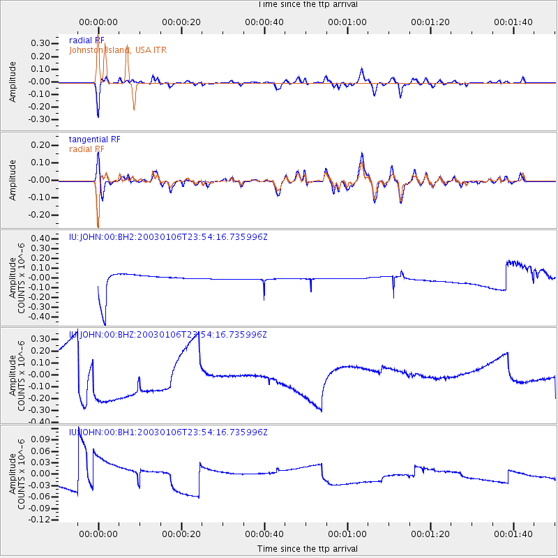
Signal To Noise
| Channel | StoN | STA | LTA |
| IU:JOHN:00:BHZ:20030106T23:54:16.735996Z | 4.7620273 | 3.6206637E-7 | 7.603199E-8 |
| IU:JOHN:00:BH1:20030106T23:54:16.735996Z | 5.89271 | 5.7453462E-8 | 9.749922E-9 |
| IU:JOHN:00:BH2:20030106T23:54:16.735996Z | 0.020454839 | 2.1543405E-9 | 1.05321796E-7 |
| Arrivals |
| Ps | |
| PpPs | |
| PsPs/PpSs | |


