You are here: Home > Network List > IU - Global Seismograph Network (GSN - IRIS/USGS) Stations List
> Station RSSD Black Hills, South Dakota, USA > Earthquake Result Viewer
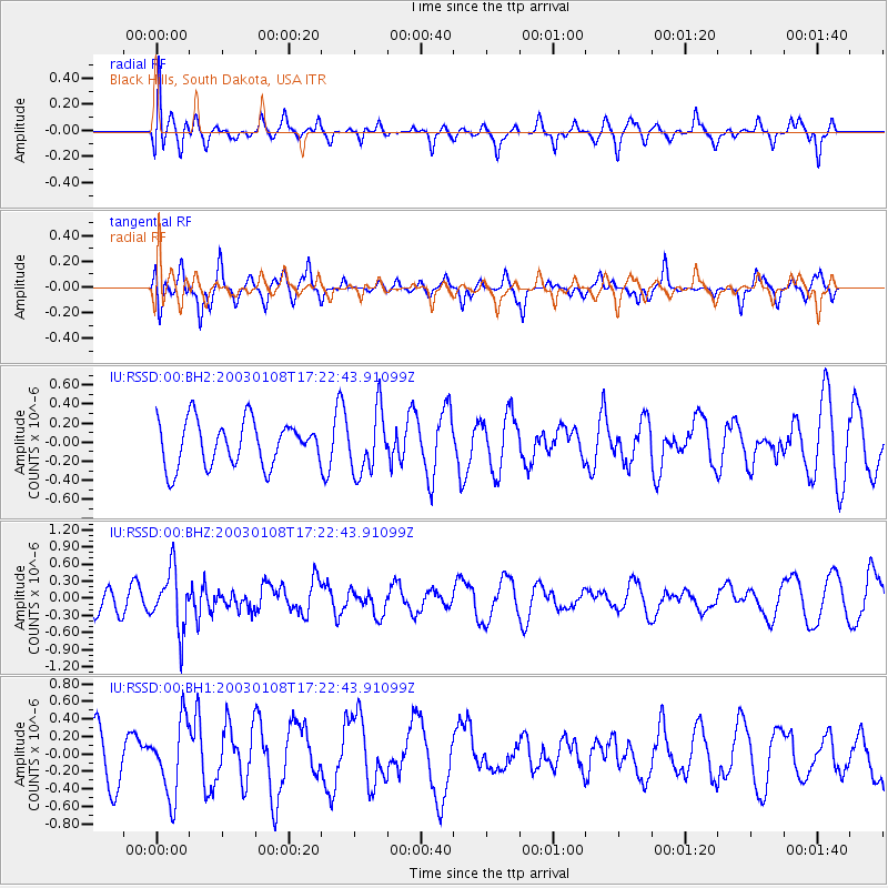
RSSD Black Hills, South Dakota, USA - Earthquake Result Viewer
*The percent match for this event was below the threshold and hence no stack was calculated.
| Earthquake location: |
Fox Islands, Aleutian Islands |
| Earthquake latitude/longitude: |
52.1/-171.6 |
| Earthquake time(UTC): |
2003/01/08 (008) 17:15:07 GMT |
| Earthquake Depth: |
33 km |
| Earthquake Magnitude: |
5.5 MW |
| Earthquake Catalog/Contributor: |
NEIC PDE/NEIC PDE-M |
|
| Network: |
IU Global Seismograph Network (GSN - IRIS/USGS) |
| Station: |
RSSD Black Hills, South Dakota, USA |
| Lat/Lon: |
44.12 N/104.04 W |
| Elevation: |
2060 m |
|
| Distance: |
44.3 deg |
| Az: |
72.365 deg |
| Baz: |
305.27 deg |
| Ray Param: |
$rayparam |
*The percent match for this event was below the threshold and hence was not used in the summary stack. |
|
| Radial Match: |
53.71772 % |
| Radial Bump: |
400 |
| Transverse Match: |
59.930218 % |
| Transverse Bump: |
336 |
| SOD ConfigId: |
590571 |
| Insert Time: |
2013-09-25 00:58:24.392 +0000 |
| GWidth: |
2.5 |
| Max Bumps: |
400 |
| Tol: |
0.001 |
|
Signal To Noise
| Channel | StoN | STA | LTA |
| IU:RSSD:00:BHZ:20030108T17:22:43.91099Z | 1.7999824 | 5.097117E-7 | 2.8317592E-7 |
| IU:RSSD:00:BH1:20030108T17:22:43.91099Z | 1.272315 | 4.2456912E-7 | 3.336981E-7 |
| IU:RSSD:00:BH2:20030108T17:22:43.91099Z | 1.3856361 | 3.2339764E-7 | 2.3339292E-7 |
| Arrivals |
| Ps | |
| PpPs | |
| PsPs/PpSs | |


