You are here: Home > Network List > IW - Intermountain West Stations List
> Station MOOW Moose Ponds, Wyoming, USA > Earthquake Result Viewer
MOOW Moose Ponds, Wyoming, USA - Earthquake Result Viewer
*The percent match for this event was below the threshold and hence no stack was calculated.
| Earthquake location: |
Sea Of Okhotsk |
| Earthquake latitude/longitude: |
47.0/145.2 |
| Earthquake time(UTC): |
2013/08/04 (216) 15:56:34 GMT |
| Earthquake Depth: |
375 km |
| Earthquake Magnitude: |
5.8 MW, 5.8 MW |
| Earthquake Catalog/Contributor: |
NEIC PDE/NEIC PDE-W |
|
| Network: |
IW Intermountain West |
| Station: |
MOOW Moose Ponds, Wyoming, USA |
| Lat/Lon: |
43.75 N/110.74 W |
| Elevation: |
2128 m |
|
| Distance: |
67.5 deg |
| Az: |
49.529 deg |
| Baz: |
314.057 deg |
| Ray Param: |
$rayparam |
*The percent match for this event was below the threshold and hence was not used in the summary stack. |
|
| Radial Match: |
66.55334 % |
| Radial Bump: |
400 |
| Transverse Match: |
55.617714 % |
| Transverse Bump: |
400 |
| SOD ConfigId: |
589702 |
| Insert Time: |
2013-09-25 01:01:58.820 +0000 |
| GWidth: |
2.5 |
| Max Bumps: |
400 |
| Tol: |
0.001 |
|
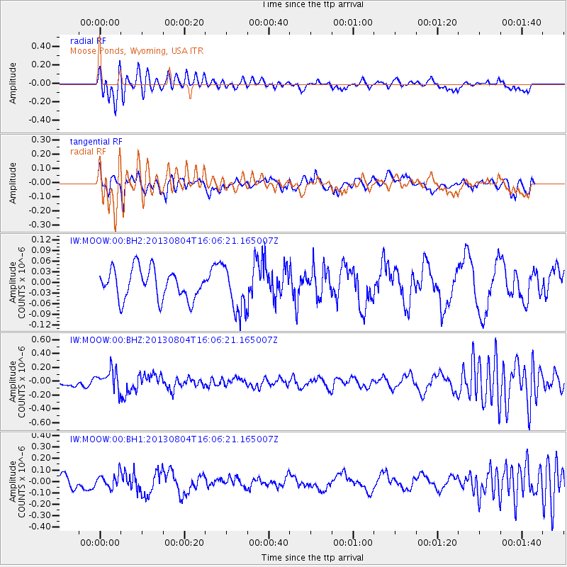
Signal To Noise
| Channel | StoN | STA | LTA |
| IW:MOOW:00:BHZ:20130804T16:06:21.165007Z | 4.895593 | 1.581017E-7 | 3.2294697E-8 |
| IW:MOOW:00:BH1:20130804T16:06:21.165007Z | 1.1159172 | 6.0851E-8 | 5.4530034E-8 |
| IW:MOOW:00:BH2:20130804T16:06:21.165007Z | 1.5747744 | 6.59871E-8 | 4.1902574E-8 |
| Arrivals |
| Ps | |
| PpPs | |
| PsPs/PpSs | |


