You are here: Home > Network List > IU - Global Seismograph Network (GSN - IRIS/USGS) Stations List
> Station JOHN Johnston Island, USA > Earthquake Result Viewer
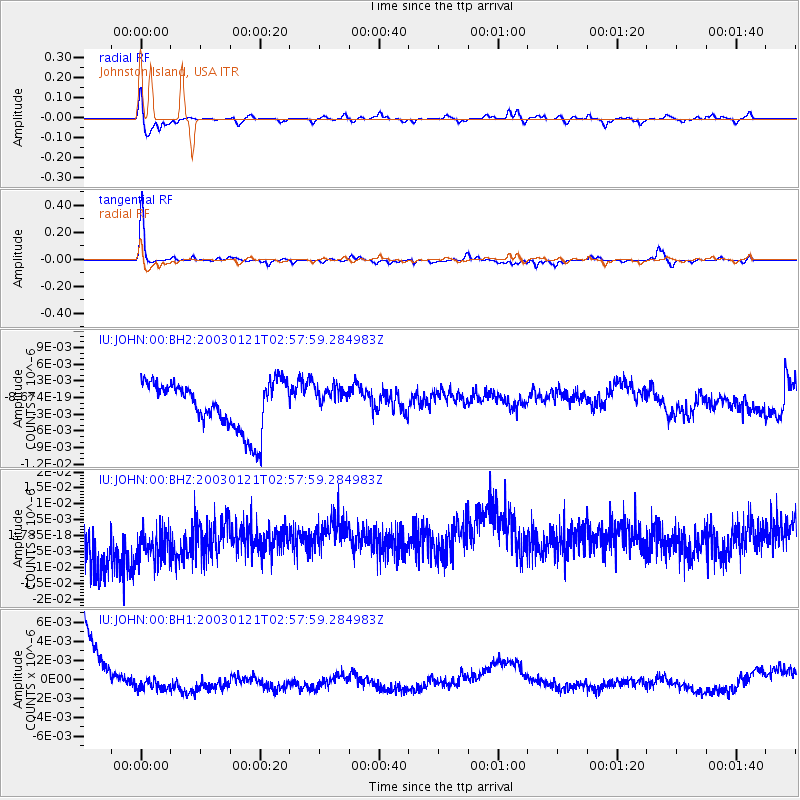
JOHN Johnston Island, USA - Earthquake Result Viewer
*The percent match for this event was below the threshold and hence no stack was calculated.
| Earthquake location: |
Near Coast Of Guatemala |
| Earthquake latitude/longitude: |
13.6/-90.8 |
| Earthquake time(UTC): |
2003/01/21 (021) 02:46:47 GMT |
| Earthquake Depth: |
24 km |
| Earthquake Magnitude: |
5.5 MB, 6.3 MS, 6.5 MW, 6.3 MW |
| Earthquake Catalog/Contributor: |
WHDF/NEIC |
|
| Network: |
IU Global Seismograph Network (GSN - IRIS/USGS) |
| Station: |
JOHN Johnston Island, USA |
| Lat/Lon: |
16.73 N/169.53 W |
| Elevation: |
2.0 m |
|
| Distance: |
75.6 deg |
| Az: |
284.008 deg |
| Baz: |
79.888 deg |
| Ray Param: |
$rayparam |
*The percent match for this event was below the threshold and hence was not used in the summary stack. |
|
| Radial Match: |
54.49448 % |
| Radial Bump: |
384 |
| Transverse Match: |
75.57274 % |
| Transverse Bump: |
213 |
| SOD ConfigId: |
590571 |
| Insert Time: |
2013-09-25 01:05:46.458 +0000 |
| GWidth: |
2.5 |
| Max Bumps: |
400 |
| Tol: |
0.001 |
|
Signal To Noise
| Channel | StoN | STA | LTA |
| IU:JOHN:00:BHZ:20030121T02:57:59.284983Z | 1.2443651 | 1.0695853E-8 | 8.59543E-9 |
| IU:JOHN:00:BH1:20030121T02:57:59.284983Z | 0.33017513 | 1.0687223E-9 | 3.2368348E-9 |
| IU:JOHN:00:BH2:20030121T02:57:59.284983Z | 0.59227854 | 2.5702354E-9 | 4.3395723E-9 |
| Arrivals |
| Ps | |
| PpPs | |
| PsPs/PpSs | |


