You are here: Home > Network List > IU - Global Seismograph Network (GSN - IRIS/USGS) Stations List
> Station RSSD Black Hills, South Dakota, USA > Earthquake Result Viewer
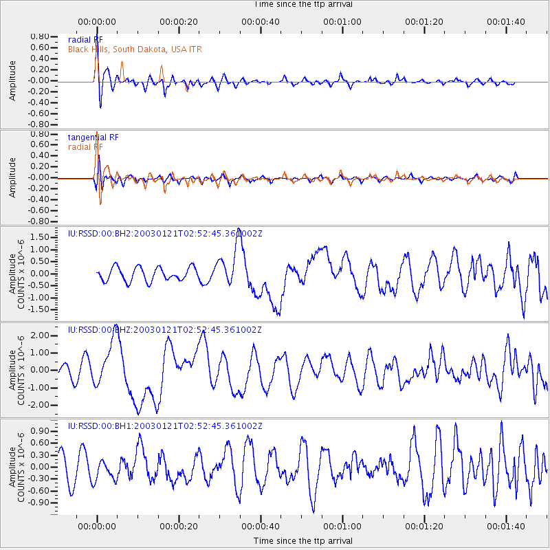
RSSD Black Hills, South Dakota, USA - Earthquake Result Viewer
*The percent match for this event was below the threshold and hence no stack was calculated.
| Earthquake location: |
Near Coast Of Guatemala |
| Earthquake latitude/longitude: |
13.6/-90.8 |
| Earthquake time(UTC): |
2003/01/21 (021) 02:46:47 GMT |
| Earthquake Depth: |
24 km |
| Earthquake Magnitude: |
5.5 MB, 6.3 MS, 6.5 MW, 6.3 MW |
| Earthquake Catalog/Contributor: |
WHDF/NEIC |
|
| Network: |
IU Global Seismograph Network (GSN - IRIS/USGS) |
| Station: |
RSSD Black Hills, South Dakota, USA |
| Lat/Lon: |
44.12 N/104.04 W |
| Elevation: |
2060 m |
|
| Distance: |
32.4 deg |
| Az: |
342.062 deg |
| Baz: |
155.433 deg |
| Ray Param: |
$rayparam |
*The percent match for this event was below the threshold and hence was not used in the summary stack. |
|
| Radial Match: |
75.34035 % |
| Radial Bump: |
400 |
| Transverse Match: |
54.222687 % |
| Transverse Bump: |
400 |
| SOD ConfigId: |
590571 |
| Insert Time: |
2013-09-25 01:05:52.629 +0000 |
| GWidth: |
2.5 |
| Max Bumps: |
400 |
| Tol: |
0.001 |
|
Signal To Noise
| Channel | StoN | STA | LTA |
| IU:RSSD:00:BHZ:20030121T02:52:45.361002Z | 3.5575304 | 1.3513283E-6 | 3.7985012E-7 |
| IU:RSSD:00:BH1:20030121T02:52:45.361002Z | 0.7347562 | 2.4160892E-7 | 3.288287E-7 |
| IU:RSSD:00:BH2:20030121T02:52:45.361002Z | 3.0136828 | 8.406282E-7 | 2.789372E-7 |
| Arrivals |
| Ps | |
| PpPs | |
| PsPs/PpSs | |


