You are here: Home > Network List > CN - Canadian National Seismograph Network Stations List
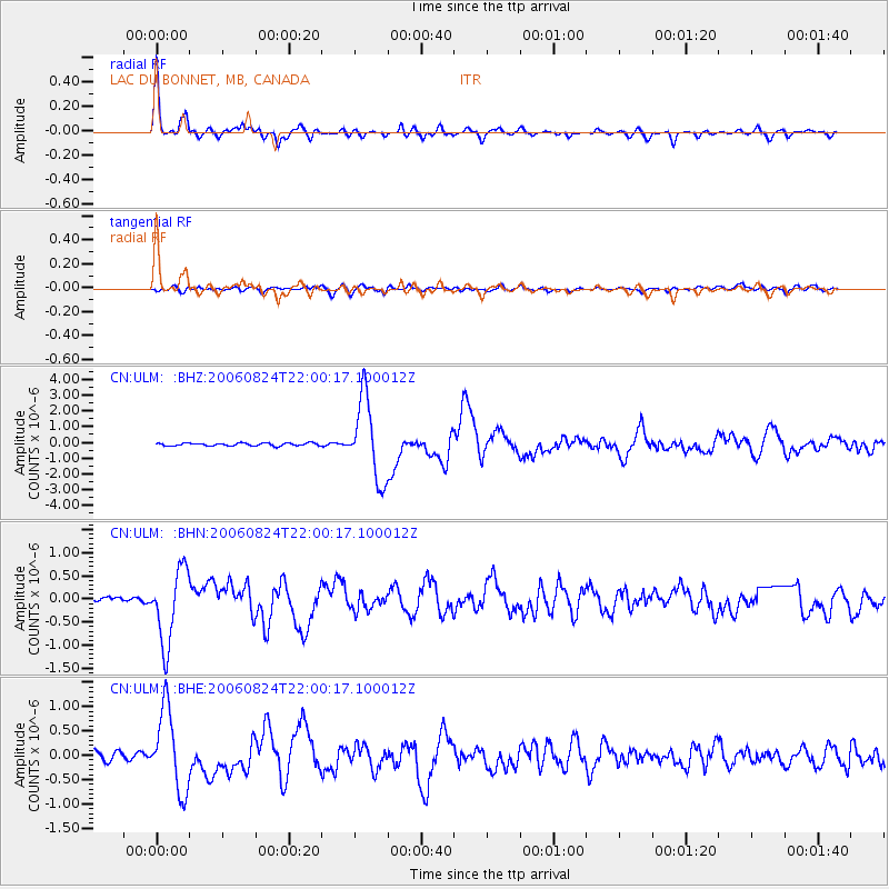
> Station ULM LAC DU BONNET, MB, CANADA > Earthquake Result Viewer
ULM LAC DU BONNET, MB, CANADA - Earthquake Result Viewer
| Earthquake location: |
Near East Coast Of Kamchatka |
| Earthquake latitude/longitude: |
51.1/157.5 |
| Earthquake time(UTC): |
2006/08/24 (236) 21:50:36 GMT |
| Earthquake Depth: |
43 km |
| Earthquake Magnitude: |
5.9 MB, 6.2 MS, 6.5 MW, 6.5 MW |
| Earthquake Catalog/Contributor: |
WHDF/NEIC |
|
| Network: |
CN Canadian National Seismograph Network |
| Station: |
ULM LAC DU BONNET, MB, CANADA |
| Lat/Lon: |
50.25 N/95.87 W |
| Elevation: |
251 m |
|
| Distance: |
61.3 deg |
| Az: |
44.529 deg |
| Baz: |
316.525 deg |
| Ray Param: |
0.060865764 |
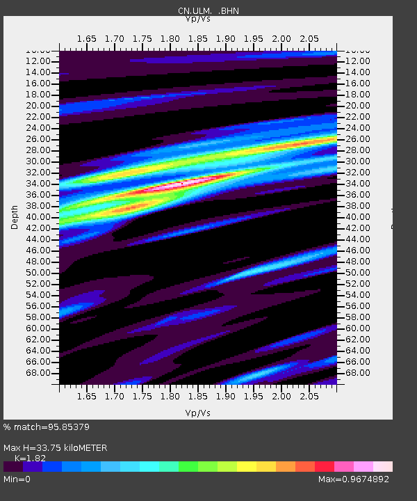
| Estimated Moho Depth: |
33.75 km |
| Estimated Crust Vp/Vs: |
1.82 |
| Assumed Crust Vp: |
6.459 km/s |
| Estimated Crust Vs: |
3.549 km/s |
| Estimated Crust Poisson's Ratio: |
0.28 |
|
| Radial Match: |
95.85379 % |
| Radial Bump: |
383 |
| Transverse Match: |
79.51413 % |
| Transverse Bump: |
400 |
| SOD ConfigId: |
2564 |
| Insert Time: |
2010-02-27 07:34:18.251 +0000 |
| GWidth: |
2.5 |
| Max Bumps: |
400 |
| Tol: |
0.001 |
|
Signal To Noise
| Channel | StoN | STA | LTA |
| CN:ULM: :BHN:20060824T22:00:17.100012Z | 14.703982 | 7.9853004E-7 | 5.430706E-8 |
| CN:ULM: :BHE:20060824T22:00:17.100012Z | 11.2445755 | 8.3036826E-7 | 7.384612E-8 |
| CN:ULM: :BHZ:20060824T22:00:17.100012Z | 28.739613 | 2.5396748E-6 | 8.8368445E-8 |
| Arrivals |
| Ps | 4.5 SECOND |
| PpPs | 14 SECOND |
| PsPs/PpSs | 19 SECOND |


