You are here: Home > Network List > IU - Global Seismograph Network (GSN - IRIS/USGS) Stations List
> Station JOHN Johnston Island, USA > Earthquake Result Viewer
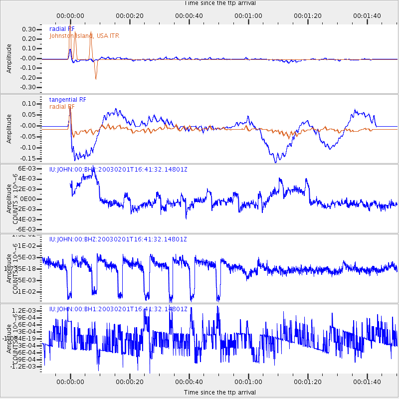
JOHN Johnston Island, USA - Earthquake Result Viewer
*The percent match for this event was below the threshold and hence no stack was calculated.
| Earthquake location: |
Chiapas, Mexico |
| Earthquake latitude/longitude: |
16.6/-92.9 |
| Earthquake time(UTC): |
2003/02/01 (032) 16:30:57 GMT |
| Earthquake Depth: |
211 km |
| Earthquake Magnitude: |
5.8 MW, 5.8 MW |
| Earthquake Catalog/Contributor: |
NEIC PDE/NEIC PDE-M |
|
| Network: |
IU Global Seismograph Network (GSN - IRIS/USGS) |
| Station: |
JOHN Johnston Island, USA |
| Lat/Lon: |
16.73 N/169.53 W |
| Elevation: |
2.0 m |
|
| Distance: |
72.9 deg |
| Az: |
282.797 deg |
| Baz: |
77.438 deg |
| Ray Param: |
$rayparam |
*The percent match for this event was below the threshold and hence was not used in the summary stack. |
|
| Radial Match: |
74.7112 % |
| Radial Bump: |
400 |
| Transverse Match: |
64.77429 % |
| Transverse Bump: |
400 |
| SOD ConfigId: |
590571 |
| Insert Time: |
2013-09-25 01:10:44.095 +0000 |
| GWidth: |
2.5 |
| Max Bumps: |
400 |
| Tol: |
0.001 |
|
Signal To Noise
| Channel | StoN | STA | LTA |
| IU:JOHN:00:BHZ:20030201T16:41:32.14801Z | 1.162051 | 6.653718E-9 | 5.72584E-9 |
| IU:JOHN:00:BH1:20030201T16:41:32.14801Z | 1.0301955 | 5.3236426E-10 | 5.1676047E-10 |
| IU:JOHN:00:BH2:20030201T16:41:32.14801Z | 0.78930646 | 1.922605E-9 | 2.4358155E-9 |
| Arrivals |
| Ps | |
| PpPs | |
| PsPs/PpSs | |


