You are here: Home > Network List > TA - USArray Transportable Network (new EarthScope stations) Stations List
> Station N40A Mertquake, Salem, IA, USA > Earthquake Result Viewer
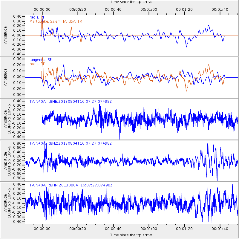
N40A Mertquake, Salem, IA, USA - Earthquake Result Viewer
*The percent match for this event was below the threshold and hence no stack was calculated.
| Earthquake location: |
Sea Of Okhotsk |
| Earthquake latitude/longitude: |
47.0/145.2 |
| Earthquake time(UTC): |
2013/08/04 (216) 15:56:34 GMT |
| Earthquake Depth: |
375 km |
| Earthquake Magnitude: |
5.8 MW, 5.8 MW |
| Earthquake Catalog/Contributor: |
NEIC PDE/NEIC PDE-W |
|
| Network: |
TA USArray Transportable Network (new EarthScope stations) |
| Station: |
N40A Mertquake, Salem, IA, USA |
| Lat/Lon: |
40.88 N/91.58 W |
| Elevation: |
208 m |
|
| Distance: |
79.0 deg |
| Az: |
40.268 deg |
| Baz: |
324.295 deg |
| Ray Param: |
$rayparam |
*The percent match for this event was below the threshold and hence was not used in the summary stack. |
|
| Radial Match: |
48.693474 % |
| Radial Bump: |
400 |
| Transverse Match: |
44.28825 % |
| Transverse Bump: |
400 |
| SOD ConfigId: |
589702 |
| Insert Time: |
2013-09-25 01:15:24.677 +0000 |
| GWidth: |
2.5 |
| Max Bumps: |
400 |
| Tol: |
0.001 |
|
Signal To Noise
| Channel | StoN | STA | LTA |
| TA:N40A: :BHZ:20130804T16:07:27.07498Z | 3.1496243 | 2.771294E-7 | 8.7988084E-8 |
| TA:N40A: :BHN:20130804T16:07:27.07498Z | 1.5789837 | 1.457709E-7 | 9.2319446E-8 |
| TA:N40A: :BHE:20130804T16:07:27.07498Z | 1.7714418 | 1.2834504E-7 | 7.24523E-8 |
| Arrivals |
| Ps | |
| PpPs | |
| PsPs/PpSs | |


