You are here: Home > Network List > TA - USArray Transportable Network (new EarthScope stations) Stations List
> Station N56A West Decatur, PA, USA > Earthquake Result Viewer
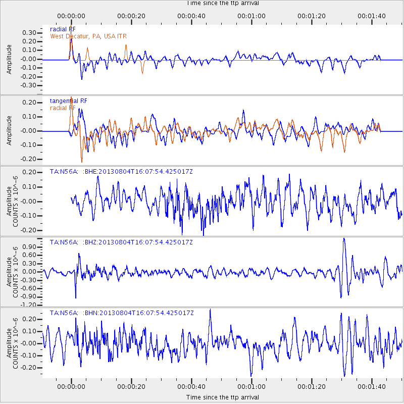
N56A West Decatur, PA, USA - Earthquake Result Viewer
*The percent match for this event was below the threshold and hence no stack was calculated.
| Earthquake location: |
Sea Of Okhotsk |
| Earthquake latitude/longitude: |
47.0/145.2 |
| Earthquake time(UTC): |
2013/08/04 (216) 15:56:34 GMT |
| Earthquake Depth: |
375 km |
| Earthquake Magnitude: |
5.8 MW, 5.8 MW |
| Earthquake Catalog/Contributor: |
NEIC PDE/NEIC PDE-W |
|
| Network: |
TA USArray Transportable Network (new EarthScope stations) |
| Station: |
N56A West Decatur, PA, USA |
| Lat/Lon: |
40.92 N/78.30 W |
| Elevation: |
561 m |
|
| Distance: |
84.3 deg |
| Az: |
31.627 deg |
| Baz: |
331.724 deg |
| Ray Param: |
$rayparam |
*The percent match for this event was below the threshold and hence was not used in the summary stack. |
|
| Radial Match: |
40.337746 % |
| Radial Bump: |
400 |
| Transverse Match: |
52.964622 % |
| Transverse Bump: |
400 |
| SOD ConfigId: |
589702 |
| Insert Time: |
2013-09-25 01:15:46.274 +0000 |
| GWidth: |
2.5 |
| Max Bumps: |
400 |
| Tol: |
0.001 |
|
Signal To Noise
| Channel | StoN | STA | LTA |
| TA:N56A: :BHZ:20130804T16:07:54.425017Z | 3.2841153 | 2.7536512E-7 | 8.3847574E-8 |
| TA:N56A: :BHN:20130804T16:07:54.425017Z | 1.2686495 | 1.11075515E-7 | 8.755415E-8 |
| TA:N56A: :BHE:20130804T16:07:54.425017Z | 1.2320464 | 7.243271E-8 | 5.8790572E-8 |
| Arrivals |
| Ps | |
| PpPs | |
| PsPs/PpSs | |


