You are here: Home > Network List > IU - Global Seismograph Network (GSN - IRIS/USGS) Stations List
> Station JOHN Johnston Island, USA > Earthquake Result Viewer
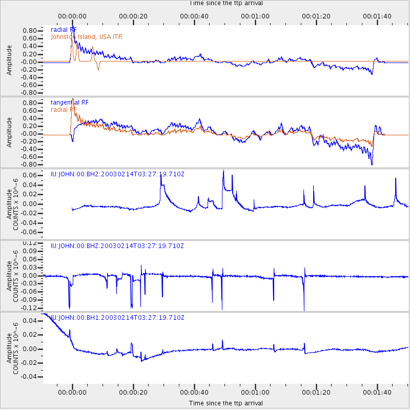
JOHN Johnston Island, USA - Earthquake Result Viewer
*The percent match for this event was below the threshold and hence no stack was calculated.
| Earthquake location: |
Tonga Islands |
| Earthquake latitude/longitude: |
-16.4/-173.3 |
| Earthquake time(UTC): |
2003/02/14 (045) 03:21:16 GMT |
| Earthquake Depth: |
33 km |
| Earthquake Magnitude: |
5.7 MW, 5.5 MS, 5.7 MW |
| Earthquake Catalog/Contributor: |
NEIC PDE/NEIC PDE-M |
|
| Network: |
IU Global Seismograph Network (GSN - IRIS/USGS) |
| Station: |
JOHN Johnston Island, USA |
| Lat/Lon: |
16.73 N/169.53 W |
| Elevation: |
2.0 m |
|
| Distance: |
33.2 deg |
| Az: |
6.65 deg |
| Baz: |
186.66 deg |
| Ray Param: |
$rayparam |
*The percent match for this event was below the threshold and hence was not used in the summary stack. |
|
| Radial Match: |
39.51609 % |
| Radial Bump: |
400 |
| Transverse Match: |
16.215326 % |
| Transverse Bump: |
400 |
| SOD ConfigId: |
590571 |
| Insert Time: |
2013-09-25 01:16:38.747 +0000 |
| GWidth: |
2.5 |
| Max Bumps: |
400 |
| Tol: |
0.001 |
|
Signal To Noise
| Channel | StoN | STA | LTA |
| IU:JOHN:00:BHZ:20030214T03:27:19.710Z | 13.702833 | 2.6985225E-8 | 1.9693172E-9 |
| IU:JOHN:00:BH1:20030214T03:27:19.710Z | 0.31836498 | 2.5053293E-8 | 7.8693624E-8 |
| IU:JOHN:00:BH2:20030214T03:27:19.710Z | 11.344972 | 2.8148325E-8 | 2.4811277E-9 |
| Arrivals |
| Ps | |
| PpPs | |
| PsPs/PpSs | |


